
December 11, 2020:
In mid-September the Canadian Coast Guard received several reports of sheen on the water in Zuciarte Channel near the east end of Bligh Island in Nootka Sound, British Columbia. An initial investigation did not turn up a source and it was thought that the sheen was created by bilge discharge from vessels transiting through the area. However, recently locals reported seeing an increase in the frequency and amount of sheen and after further investigation Coast Guard has identified a historic shipwreck, the MV Schiedyk, as the source of the marine pollution.
A Incident Command Post (ICP) has been set up and the Canadian Coast Guard and the BC Ministry of Environment and Climate Change Strategy, Mowachaht/Muchalaht First Nation, Hesquiaht First Nation, Nuu-chah-nulth Tribal Council, Environment and Climate Change Canada, Fisheries and Oceans Canada, Western Canada Marine Response, and other partners are working together to respond to the situation. The ICP is under the direction of a Unified Command shared between the Canadian Coast Guard and the BC Ministry of Environment and Climate Change Strategy, and due to COVID restrictions, the ICP is operating virtually as much as possible.
The current amount of marine pollution upwelling from the area is minimal, and we are taking action now to assess and contain the immediate threat to prevent long term damage to the environment.
Right now we are:
- Deploying a ROV to gain a better understanding of the condition of the shipwreck, where the fuel may be leaking from, and, if possible, to get an idea of how much fuel is onboard.
- Establishment of an Environmental Unit including representatives of Mowachat/Muchalaht, Hesquiaht, Ehattesaht Chinehkint First Nations, and the Nuu Chah Nulth Tribal Council.
- Mowachat/Muchalaht, Hesquiaht and Nuu Chah Nulth Tribal council representatives are providing valuable local knowledge about the area, and identifying sensitive ecological and archaeological sites.
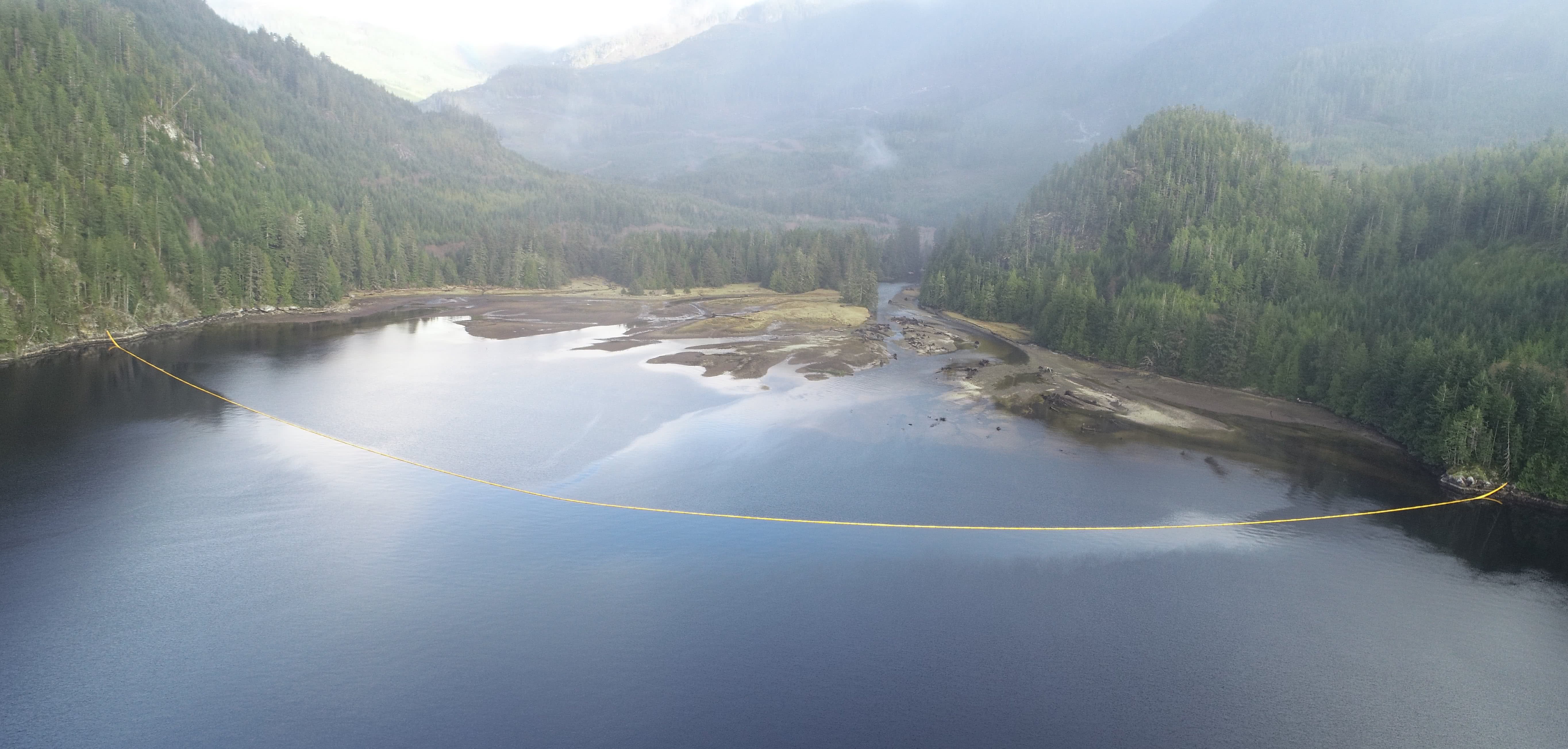
- Identification of seven sites of ecological and archaeological sensitivity; approximately 10,000 feet of boom has been deployed to protect those sites.
- Taking samples to confirm the type of fuel upwelling in the area. The current amount of oil upwelling is between 30-50 litres.
- Air surveillance of the area by drones and National Aerial Surveillance Program (NASP) overflights by Transport Canada to assess the spread and direction of marine pollution, and support tactical response efforts.
- Mapping sensitive shoreline and cultural sites and developing wildlife and shoreline assessment plans.
- Deploying Fisheries and Oceans Marine Mammal Oil Spill Response Team to survey the area for potentially impacted mammals.
- Gathering historic information on the MV Schiedyk including fuel capacity of the ship, location of fuel tanks, and the original reports of the shipwreck.
Once the Unified Command has made these assessments and taken initial action to protect sensitive areas, longer term strategies and tactics will be developed for containment and protection, and ongoing information gathering will determine the action plan. We expect that on-water and on-site operations will be dependent on weather and sea conditions in the area as work progresses this winter.
Quick Facts
- The shipwreck MV Schiedyk:
- A 483ft cargo ship built in Belfast, Ireland in 1948.
- On January 3, 1968 the MV Schiedyk departed Gold River with a cargo of 2,130 tons of wood pulp and 1000 tons of bulk barley on route to Portland, Oregon.
- Later that day the ship struck a submerged ledge on the south side of Bligh Island, causing extensive damage including a 100 metre gash in the hull.
- Before the 34 crew members abandoned ship, oil was reported on the water but we don’t know how much escaped at that time.
- Near midnight the ship floated off the ledge and drifted down Zuciarte Channel before grounding again on the east side of Bligh Island.
- Sonar indicates the shipwreck is in 360-400ft of water on the east side of Bligh Island.
- News coverage from 1968:
- Bligh Island is within the traditional territory of the Mowachaht/Muchalaht First Nation.
- The Bligh Island Marine Park encompasses the southern portion of Bligh Island, Villaverde Islands, Pantoja Islands, Verdia Island, Vernaci Island and Spouter Island in Nootka Sound. Blight Island is home to mature coastal forests and within the Spanish Pilot Group of Islands, an area popular recreational destination for anglers, boaters and kayakers.
- The Incident Command System (ICS) is a system used to manage an incident with a standardized approach to the command, control and coordination of emergency response. The ICS helps responders from multiple organisations working together effectively. In the Bligh Island Shipwreck response, we are using a Unified Command to establish a common set of objectives and strategies and an Incident Action Plan.
- Response crews are following all COVID-protocols including wearing masks and other PPE, social distancing, and avoiding travel to small communities whenever possible.
- Members of the public can report oil and oiled wildlife sightings for this incident to: 1-888-801-5860
Resources for media:
Name of the ship is pronounced: shkee-dike
Photos and video and other information for media can be found at: SpillResponsebc.ca This site will be kept updated as the response progresses.
Underwater and drone footage of the site, and taped interviews with the Unified Commanders Tyler Yager, Canadian Coast Guard, and Dave Pridham, BC Ministry of Environment and Climate Change Strategy is available.
Please note: due to COVID health orders issued by the Mowachaht/Muchalaht First Nation and Nuu-chah-nulth Tribal Council, and to protect the health and safety of incident response crews working at the site, media are asked to avoid travelling to the area at this time. We will be posting new photos and video to the SpillResponsebc.ca as much as possible.
Information Officer
Bligh Island Shipwreck Response
Kiri.Westnedge@dfo-mpo.gc.ca
250-508-2038
(Francais)
L’épave de l’île Bligh
Déclaration du commandement unifié
Le 11 décembre 2020
À la mi-septembre, la Garde côtière canadienne a reçu plusieurs rapports faisant état d’une irisation d’hydrocarbures sur l’eau dans le chenal de Zuciarte, près de l’extrémité est de l’île Bligh, dans le détroit de Nootka, en Colombie-Britannique. L’enquête initiale n’a pas permis de trouver de source et on a pensé que l’irisation était due à l’écoulement de la cale des navires transitant dans la zone. Cependant, les résidents locaux ont récemment signalé avoir constaté une augmentation de la fréquence et de la quantité de reflets sur l’eau et, après une enquête plus approfondie, la Garde côtière a identifié une épave historique, le NM Schiedyk, comme étant la source de la pollution marine.
Un poste de commandement d’incident (PCI) a été mis en place et la Garde côtière canadienne, le ministère de l’Environnement et de la Stratégie sur le changement climatique de la Colombie-Britannique, la Première Nation Mowachaht/Muchalaht, la Première Nation Hesquiaht, Environnement et Changement climatique Canada, Pêches et Océans Canada, West Coast Marine Response, le Conseil tribal Nuu-chah-nulth, et d’autres partenaires travaillent ensemble pour répondre à la situation. Le PCI est dirigé grâce à un commandement unifié partagé entre la Garde côtière canadienne et le ministère de l’Environnement et de la Stratégie sur le changement climatique de la Colombie-Britannique. En raison des mesures de sécurité imposées par la COVID, le PCI fonctionne autant que possible de manière virtuelle.
La quantité actuelle de pollution marine en amont de la zone est minime, et nous prenons des mesures dès maintenant pour évaluer et contenir la menace immédiate, afin de prévenir les dommages à long terme à l’environnement.
Pour le moment, nous prenons les mesures suivantes :
- Déploiement d’un véhicule sous-marin téléguidé (ROV) pour mieux comprendre l’état du naufrage, d’où le carburant peut s’échapper et, si possible, pour avoir une idée de la quantité de carburant à bord.
- Identification de sept sites sensibles sur le plan écologique et culturel; environ 10 000 pieds de barrage ont été déployés pour protéger ces sites.
- Prélèvement d’échantillons pour confirmer le type de remontée de carburant dans la zone. La quantité actuelle de remontée d’hydrocarbures se situe entre 30 et 50 litres.
- Surveillance aérienne de la zone par des drones et survols du Programme national de surveillance aérienne (PNSA) par Transports Canada, pour évaluer la propagation et la direction de la pollution marine et soutenir les tactiques d’intervention.
- Cartographie des sites côtiers et culturels sensibles, et élaboration de plans d’évaluation de la faune et du littoral.
- Déploiement de l’équipe d’intervention de Pêches et Océans Canada pour les mammifères marins en cas de déversement d’hydrocarbures, afin d’étudier la zone pour les mammifères potentiellement touchés.
- Établissement des données historiques sur le NM Schiedyk, y compris la capacité en carburant du navire, l’emplacement des réservoirs de carburant et les rapports originaux sur le naufrage.
Une fois que le commandement unifié aura effectué ces évaluations et pris des mesures initiales pour protéger les zones sensibles, des stratégies et des tactiques à plus long terme seront élaborées pour le confinement et la protection, et la collecte continue d’informations déterminera le plan d’action. Nous prévoyons que les opérations sur l’eau et sur site dépendront des conditions météorologiques et de l’état de la mer dans la région à mesure que les travaux progresseront cet hiver.
Faits en bref
- L’épave du NM Schiedyk :
- Un cargo de 483 pieds construit à Belfast, en Irlande, en 1948.
- Le 3 janvier 1968, le NM Schiedyk a quitté Gold River avec une cargaison de 2 130 tonnes de pâte de bois et de 1 000 tonnes d’orge en vrac, à destination de Portland, Oregon.
- Plus tard dans la journée, le navire a heurté une corniche submergée sur la côte sud de l’île Bligh, causant des dommages importants, dont une entaille de 100 mètres dans la coque.
- Avant que les 34 membres de l’équipage n’abandonnent le navire, on a signalé la présence d’hydrocarbures sur l’eau, mais nous ignorons quelle quantité s’est échappée à ce moment-là.
- Vers minuit, le navire a flotté au large de la corniche et a dérivé dans le chenal de Zuciarte avant de s’échouer à nouveau sur la côte est de l’île Bligh.
- Le sonar indique que l’épave se trouve dans 360-400 pieds d’eau sur la côte est de l’île Bligh.
- L’île Bligh se trouve sur le territoire traditionnel de la Première Nation Mowachaht/Muchalaht.
- Le parc marin de l’île Bligh comprend la partie sud de l’île Bligh, les îles Villaverde, Pantoja, Verdia, Vernaci et Spouter dans la baie Nootka. L’île Bligh abrite des forêts côtières matures et fait partie de l’archipel Pilot Group, une destination de loisirs populaire pour les pêcheurs, les plaisanciers et les kayakistes.
- Le système de commandement en cas d’incident (SCI) est un système utilisé pour gérer un incident avec une approche standardisée du commandement, du contrôle et de la coordination de l’intervention d’urgence. Le SCI aide les intervenants de plusieurs organisations à travailler ensemble de manière efficace. Dans le cadre de l’intervention sur le naufrage de l’île Bligh, nous utilisons un commandement unifié pour établir un ensemble commun d’objectifs et de stratégies ainsi qu’un plan d’action en cas d’incident.
- Les équipes d’intervention suivent tous les protocoles liés à la COVID, y compris le port de masques et autres PPI, la distanciation physique et l’évitement des déplacements vers de petites communautés chaque fois que cela est possible.
- Les membres du public peuvent signaler les observations d’hydrocarbures et de faune mazoutée pour cet incident, en composant le 1-888-801-5860
Ressources pour les médias :
Des photos et des vidéos ainsi que d’autres renseignements destinés aux médias sont disponibles à l’adresse suivante SpillResponsebc.ca. Ce site sera mis à jour au fur et à mesure de l’évolution de l’intervention.
Des entretiens enregistrés des membres du commandement unifié sont disponibles pour les médias, ici :
- Tyler Yager, Garde côtière canadienne
- Dave Pridham, ministère de l’Environnement et de la Stratégie sur le changement climatique de la Colombie-Britannique
Pour plus d’information :
Kiri Westnedge
Agent d’information
Épave de l’île Bligh
250-508-2038