
| SITREP | |
| Incident: | BLIGH ISLAND SHIPWRECK |
| Incident Start Date | DECEMBER 3, 2020 |
| Location: | BLIGH ISLAND, VANCOUVER ISLAND |
|
Situational Overview |
As a result of a number of sightings of sheening and oiling in the vicinity of Bligh Island / Zuciarte Channel, CCG confirms that the shipwreck of the M/V Schiedyk, a 483 ft bulk carrier that sank in 1968, has started to release oil.
The situation escalated between Dec 4-6, and heavy oil was observed on the water and staining rocks on the shoreline. As a result the Canadian Coast Guard (CCG) contracted the Western Canada Marine Response Corporation (WCMRC) to deploy to the area. CCG has established an Incident Command System (ICS) for this incident. Unified Command consists of Canadian Coast Guard, Mowachaht/Muchalaht First Nation, and BC Ministry of Environment and Climate Change Strategies. Remotely operated vehicle (ROV) operations report that the product is seeping from more than one location and that vessel is resting hull-up in 350–400 ft (100 –120 m) of water. M/V Schiedyk was carrying approximately 1000 tons of grain and pulp when it grounded. Fuel samples have been sent to Environment and Climate Change Canada’s Pacific Environmental Science Center (PESC) and Emergencies Science and Technology Section (ESTS) laboratories from forensic chemistry and fate and behavior modeling. Oil sampling test results indicate oil is similar to historical Bunker “C” type. Rate of oil upwelling was approximately 1 – 4 L per hour, with an occasional increase to approximately 11 – 13 L per hour due to weather conditions. The incident public website is updated regularly. CCG has cancelled the Transport Canada National Aerial Surveillance Program (NASP) flight tasking of the area. Upwelling is being monitored via on-water assets and Remotely Piloted Aircraft System (RPAS). Resolve Marine, the company who completed the Technical Assessment (TA) at the wreck site, arrived in Nootka Sound on April 18, 2021 on the vessel, Atlantic Condor. Hull was scrubbed, hull thickness was measured, and a patch was put in place over a 11 m gash on the starboard side. The patch has decreased the upwelling however release continues at the wreck site (attempting to quantify actual release rate – more information to follow in the following week or so). All vessel hull drilling has been completed. Four tanks were found to have product with quantities of note, predominantly heavy fuel oil with some marine diesel. The Technical Assessment operation was completed on May 4th. Resolve Marine Group and the Atlantic Condor have departed the site. Daily preventative actions are being taken to contain the immediate threats and prevent long-term impacts to the environment. Large amounts of off-shore boom have been placed to assist with heavy fuel oil containment. South of the wreck site, deflection booming has been set up. Five Geographic Response Strategies (GRS) are currently implemented across ecologically sensitive areas. |
| Incident Priorities | · Maximize response staff integration across organizations.
· Ensure safety of responders and the public. · Ensure a unified response effort to include Federal, Provincial, and Indigenous priorities. · Minimize impacts to ecological, socio-economic, and cultural areas. · Ensure fluid and efficient incident communication is easily accessible. · Ensure efficiency in marine operations. |
| Agencies Involved (either in person or remote) | · Unified Command – Canadian Coast Guard, Mowachaht/Muchalaht First Nation, BC Ministry of Environment and Climate Change Strategy
· Canadian Coast Guard · National Environmental Emergencies Centre, Environment and Climate Change Canada · BC Ministry of Environment and Climate Change Strategy · Western Canada Marine Response Corporation · Ehattesaht Fisheries · Nuu Chah Nulth Tribal Council · Mowachaht/Muchalaht First Nation · Hesquiaht First Nation · BC Parks · Fisheries and Oceans Canada · Canadian Wildlife Service · Grieg Seafood
|
Incident Management Team (IMT): UNIT UPDATES
OPERATIONS
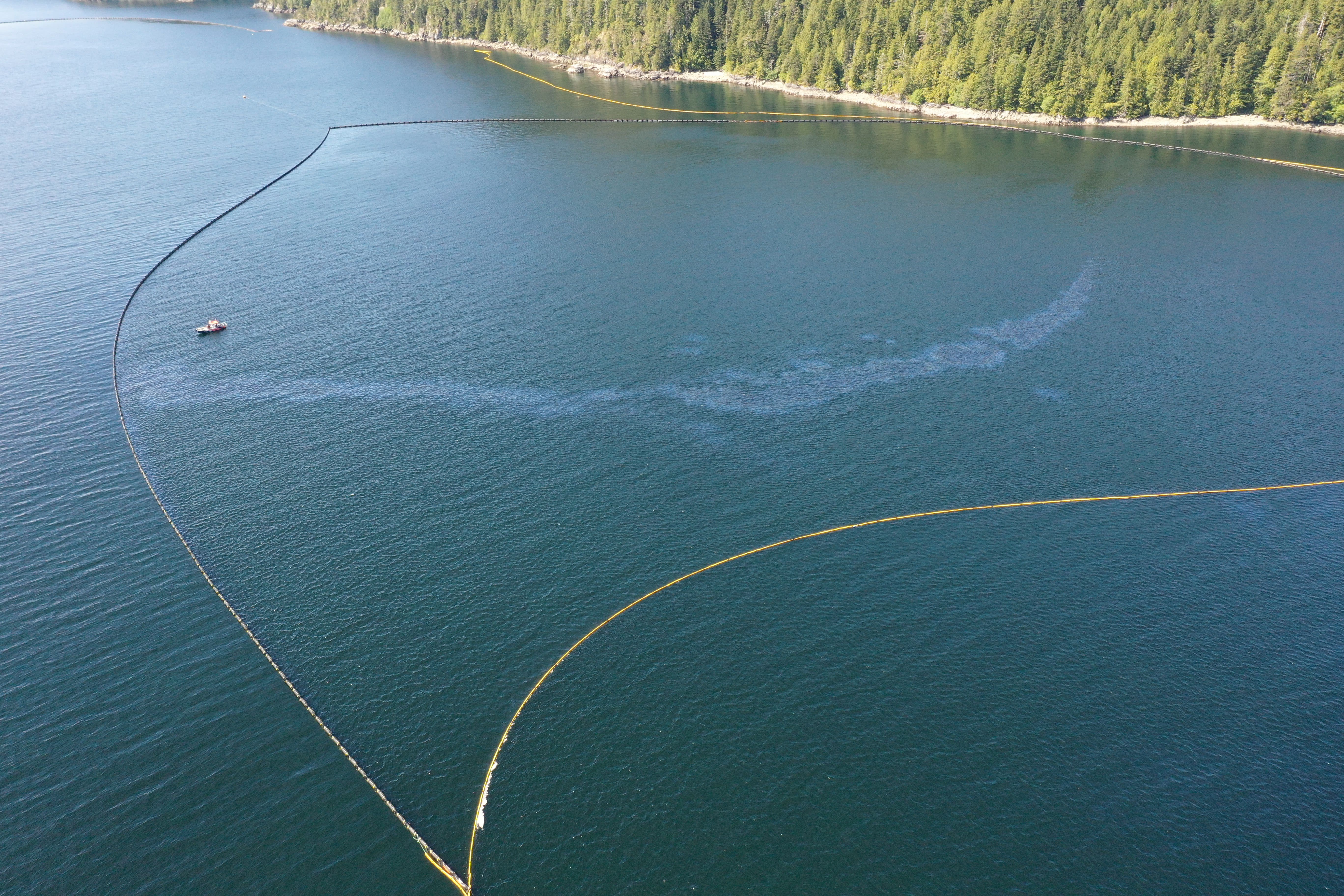
Summary: In-field operations to meet incident objectives are using a combination of floating, sub-sea and aerial resources. These resources provide direction daily, and conduct assignments like Aerial Observation, Protection Booming, Wreck Assessment, surface oil collection and recovery, as well as marine mammal and wildlife assessment. Operations staff are working out of Nootka Sound and Gold River, and following integrated Safety, Communications, and Logistical plans. Planning for these tactical operations is risk-based, and determined through a planning cycle. Equipment such as storage tanks/bins, consumable like Personal Protective Equipment (PPE) and sorbents, as well as additional equipment for contingencies, are stored at the incident staging area near Gold River. Weather, remoteness, and a consistent upwelling of oil continue to challenge in-field operations.
- Drone images and quantification showed approximately 1.2 liters of product on the water and that the containment established is effective. (2021-05-16)
- Drone flight estimated 1.3 litres of product on water and images show a smaller sheen than past days within the containment area. (2021-05-15)
- The RoBoom containment “U” was closed off using 1750ft (530m) of curtain boom from the shoreline protection and is containing a significant amount of the product. (2021-05-15)
- Crews will close off the north section of “U” RoBoom containment using a portion of the 24” curtain boom from the shoreline protection. This will achieve a fully enclosed containment area over the wreck. (2021-05-15)
- Conducting current buster training. (2021-05-15)
- Crews are confirming amount and type of boom in all locations in the field. (2021-05-14)
- Confirmed lay flat boom is still staged in Mooyah Bay for Geographic Response Strategies (GRS) locations that are not currently deployed. (2021-05-14)
- Drone flights indicates product drifting south with some product outside of the containment area. Further investigation found product observed outside of the containment area included some emulsification and small globs of oil that were observed to be dissipating quickly. The amount was not enough to be recovered by the current buster or skimmer. Crews will continue to monitor and assess. (2021-05-13)
- Drone was unable to complete mapping today due to glare on the water from the sun. (2021-05-13)
- Training conducted with crews on bird deterrence equipment (cannons and Breco Buoy) and carcass handling. (2021-05-13)
- WCMRC and CCG performing an assessment of the boom containment area to look at options for full containment. (2021-05-12)
- Crews reported an increase in product on the water today compared to previous days and it was seen moving in a NE direction. (2021-05-12)
- Waste recovered from wreck site earlier this week: May 10 – 250lbs, May 11 – 300lbs, and May 12 – 500lbs. (2021-05-12)
- Confirmed that one High Speed Sweep System (HSSS) is deployed and ponded in Heli Bay. (2021-05-11)
- 500 ft of GRS deployed at Ewin Inlet. (2021-05-11)
- Little Mooyah Bay GRS has been taken down and boom is staged in Mooyah Bay. The GRS can be re-deployed in an hour if needed. (2021-05-11)
LOGISTICS
Summary: This incident has challenged the Incident Command Post to find innovative ways to support responders at the remote incident site while also following COVID protocols. CCG and industry have integrated to bolster the existing communication network in the area to ensure responders have a safe and dependable means to communicate with each other and the virtual Incident Command Post. By cascading private/government equipment throughout Western Canada, responders have the on-water pollution counter measure equipment required. The current lack of tourism in the area allows responders to utilize lodging that had been shut down for the off-season.
- New land lease agreement at West Coast Marine Terminals has been signed and in place. (2021-05-14)
- Communication upgrades occurring in the field. Working on a corrective maintenance trip to the repeater site now. (2021-05-12)
- The Ch. 23 repeater has lost power. (2021-05-10)
- Procurements and deliveries for various resource requests. (2021-05-10)
BOOM IN PLACE
| Location | Length of Boom (meters) |
| Bligh Island Gap GRS | 76 |
| Shoreline deflection | 300 |
| Containment North | 1445 |
| Southern containment boom | 800 |
| Northern deflection Ro-Boom | 549 |
| Shoreline protection boom | 689 |
| Anderson Point | 137 |
| Cheesish Reserve/Tuta Marina GRS | 290 |
| Cheesish Reserve NW Bay GRS | 801 |
| Cheesish Reserve SE Bay GRS | 305 |
| OIL RECOVERED
(*oil product recovered is mixed with salt water and/or organics)
|
|
| SOURCE | Amount |
| Surface Oil* | Cumulative to May 17:
37,571.36 kg |
Environmental Unit (EU): UPDATES
Summary: All measures taken by the Incident Command Post utilize the Precautionary Approach and focused on minimizing damages and maximizing efforts. This approach to incident management relies on the Environmental Unit, which is comprised of Federal, Indigenous, Provincial and industry technical specialists and makes environmental-related recommendations to Unified Command that represents the interests of all contributing Environmental Unit members. An example of an ongoing agenda item for the Environmental Unit is the regular review and update of the ICS 232, a form that documents and prioritizes the Resources at Risk. Operations then use this prioritized list of environmental, economic and cultural sensitivities to build strategies and tactics to prevent damages. These proposed tactics are presented to the Unified Command for approval.
- No significant updates. (2021-05-09 to 2021-05-14)
- Focus Wildlife conducted static bird deterrence training with response crews; carcass collection training and protocols were also reviewed. (2021-05-13)
- Survey efforts focused on Ewin Inlet and Zuciarte Channel. Product escapement was noted with the incoming tide and the area was monitored for wildlife at risk. Wind and weather conditions were seen to weather the product, significantly reducing the threat to wildlife. (2021-05-13)
- 350 individuals, including Marbled Murrelets observed northeast of Bligh Island. (2021-05-12)
- One oiled Mew gull observed northeast of Bligh Island; active deterrence continues to be effective at the wreck site. (2021-05-11)
- Focus Wildlife reported 350+ Pacific Loons amongst two very large feeding aggregations also including gulls and cormorants at the entrance to Nootka Sound; 18 Marbled Murrelets observed at Escalante Pt. (2021-05-10)
| Wildlife Species | Verified Impacted (cumulative from December 10, 2020) |
| Sea Otter | 1 |
| Common Murre | 1 |
| Common Merganser | 1 |
| Mew Gull | 14 |
| Glaucous-winged Gull | 5 |
ASSIGNED RESOURCES:
Vessels:
- Atlantic Eagle – On Water Branch Director
- CCG Moorhen
- CCGER 668 (PRV III)
- CCGER 735
- WCMRC Sentinel 31 & Sentinel 33
- Tug “W. Pearce” and staging barge Miller 201 and Crane operator
- Focus 1