
| Incident: | BLIGH ISLAND SHIPWRECK |
| Incident Start Date | DECEMBER 3, 2020 |
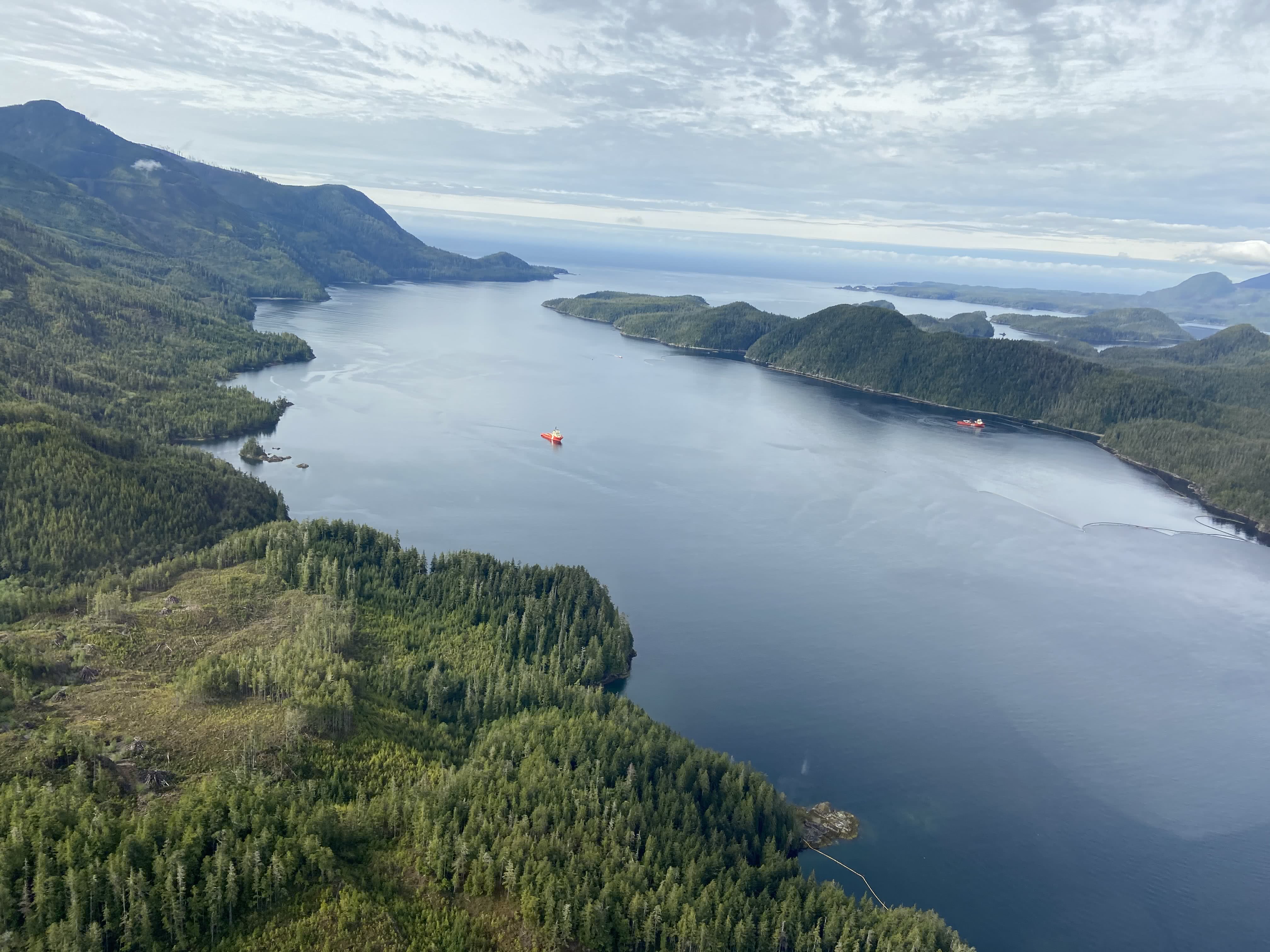
| Location: | BLIGH ISLAND, VANCOUVER ISLAND |
|
Situational Overview |
As a result of a number of sightings of sheening and oiling in the vicinity of Bligh Island / Zuciarte Channel, CCG confirms that the shipwreck of the M/V Schiedyk, a 483 ft bulk carrier that sank in 1968, has started to release oil.
The situation escalated between Dec 4-6, and heavy oil was observed on the water and staining rocks on the shoreline. As a result the Canadian Coast Guard (CCG) contracted the Western Canada Marine Response Corporation (WCMRC) to deploy to the area. CCG has established an Incident Command System (ICS) for this incident. Unified Command consists of Canadian Coast Guard, Mowachaht/Muchalaht First Nation, and BC Ministry of Environment and Climate Change Strategies. Remotely operated vehicle (ROV) operations report that the product is seeping from more than one location and that vessel is resting hull-up in 350–400 ft (100 –120 m) of water. M/V Schiedyk was carrying approximately 1000 tons of grain and pulp when it grounded. Fuel samples have been sent to Environment and Climate Change Canada’s Pacific Environmental Science Center (PESC) and Emergencies Science and Technology Section (ESTS) laboratories from forensic chemistry and fate and behavior modeling. Oil sampling test results indicate oil is similar to historical Bunker “C” type. Rate of oil upwelling was approximately 1 – 4 L per hour, with an occasional increase to approximately 11 – 13 L per hour due to weather conditions. The incident public website is updated regularly. CCG has cancelled the Transport Canada National Aerial Surveillance Program (NASP) flight tasking of the area. Upwelling is being monitored via on-water assets and Remotely Piloted Aircraft System (RPAS). Resolve Marine Group, the company completing the Technical Assessment (TA) at the wreck site, arrived in Nootka Sound on April 18, 2021 on the vessel Atlantic Condor. This week, the hull was scrubbed and patches are in place including the 10 m breach. Patches appear to be holding. Will continue to monitor for leaks during and after tank surveys. Drilling operations to determine quantity and types of product remaining onboard. Daily preventative actions are being taken to contain the immediate threats and prevent long-term damage to the environment. Large amounts of off-shore boom have been placed to assist with heavy fuel oil containment. South of the wreck site, deflection booming has been set up. Eight Geographic Response Strategies (GRS) are currently implemented across ecologically sensitive areas. |
| Incident Priorities |
|
| Agencies Involved (either in person or remote) |
|
Incident Management Team (IMT): UNIT UPDATES
OPERATIONS
Summary: In-field operations to meet incident objectives are using a combination of floating, sub-sea and aerial resources. These resources provide direction daily, and conduct assignments like Aerial Observation, Protection Booming, Wreck Assessment, surface oil collection and recovery, as well as marine mammal and wildlife assessment. Operations staff are working out of Nootka Sound and Gold River, and following integrated Safety, Communications, and Logistical plans. Planning for these tactical operations is risk-based, and determined through a planning cycle. Equipment such as storage tanks/bins, consumable like Personal Protective Equipment (PPE) and sorbents, as well as additional equipment for contingencies, are stored at the incident staging area near Gold River. Weather, remoteness, and a consistent upwelling of oil continue to challenge in-field operations.
- Drilling operations continuing with DB-1, HFO Settling Tank Starboard, and HFO Settling Tank Port. Side shell drilling will begin to determine quantities of product remaining on board. (2021-05-02)
- Drone operations reporting upwelling around the Atlantic Condor and an area of rainbow sheen collecting at Ro-boom section A2-A3. (2021-05-02)
- Drilling operations continue to progress. Initial drilling in most tanks complete. Follow up drilling required to confirm results. (2021-05-01)
- 136 kgs of soiled sorbents removed from various sites in vicinity of the wreck. (2021-05-01)
- Continued invasive sampling of tanks DB-8p and DB-8s, DB-6p and DB-6s, feedwater, 1 hole DB-2p, 1 hole DB-1 and DB-04. Found diesel oil in DB-04, which may be trace oil from adjacent oil waste tank. All drill sites sealed after drilling. (2021-04-30)
- Anderson Point GRS was repaired due to boom failure. (2021-04-30)
- Drone operations are cancelled due to weather. (2021-04-30)
- Six sandbags (special one cubic metre / half filled) arrived in Gold River today. Transferred to Miller Barge for use by Resolve team on Atlantic Condor if/as required. (2021-04-29)
- ROV completed hull survey with no additional pollution or leaks observed. (2021-04-29)
- Snares A1-A2 were replaced as they were at 70% oil saturation. (2021-04-29)
- Three sandbags with mud mat were placed over the hole last night. (2021-04-28)
- Ultrasonic Thickness (UT) testing and magnetic marking was conducted on starboard side locations. Contractor will continue with UT port side testing. (2021-04-28)
- Drill testing anticipated to begin later today. (2021-04-28)
- Crews inspected and worked on boomsticks to ensure integrity of the system. (2021-04-27)
- Re-secured the boom Section E2 to C4 (general purpose boom) attached to southern Ro-boom. (2021-04-27)
- Slackened C3 Mooring by approximately 18 m to prevent excess containment boom shifting. (2021-04-27)
- Continued UT testing conducted overnight as well as the preparation of the hull and tools for patch install continued. (2021-04-26)
- First mat in place over the gash at 1155. (2021-04-26)
- Installation of patch over 10 m gash in the ship began at 0700. (2021-04-26)
LOGISTICS
Summary: This incident has challenged the Incident Command Post to find innovative ways to support responders at the remote incident site while also following COVID protocols. CCG and industry have integrated to bolster the existing communication network in the area to ensure responders have a safe and dependable means to communicate with each other and the virtual Incident Command Post. By cascading private/government equipment throughout Western Canada, responders have the on-water pollution counter measure equipment required. The current lack of tourism in the area allows responders to utilize lodging that had been shut down for the off-season.
- Working on the cautionary buoy details for the primary Emergency Zone. (2021-04-30)
- Making arrangements for CCG Helicopter flight to the casualty site for week of May 3. (2021-04-30)
- Working on the demobilization plans. (2021-04-30)
- Continued monitoring of deliveries to Staging Area. (2021-04-29)
- Working on having 4 hazardous waste bins removed and 4 empties brought to staging. (2021-04-28)
- Supporting updates to the Demobilization plan. (2021-04-27)
- Helicopter booking for April 29. (2021-04-26)
- Organizing CCG Electronics and Informatics technicians to go to site to look after communications issues and reprogram radios. (2021-04-26)
- Working on procurements and deliveries for multiple resource requests. (2021-04-26)
- Working on next call up for marine services. (2021-04-26)
BOOM IN PLACE
| Coordinates | GRS Location | Length of Boom (metres) |
| 49°40.58’N, 126°28.21’W | Cheesish Reserve/Tuta Marina | 290 |
| 49°40.70’N, 126°28.59’W | Cheesish Reserve NW Bay | 801 |
| 49°40.40’N, 126°28.08’W | Cheesish Reserve SE Bay | 305 |
| 49°37.42’N, 126°31.02’W | Bligh Island Gap | 76 |
| 49°38.57’N, 126°28.70’W | Anderson Point | 137 |
| Shoreline deflection | 300 | |
| Containment North | 915 | |
| Ro-Boom South | 800 | |
| Little Mooyah Bay | 76 | |
| Ewin Inlet | 275 |
OIL RECOVERED
(*oil product recovered is mixed with salt water and/or organics)
| SOURCE | Amount |
| Surface Oil* | Cumulative to May 2:
36,771.81 kg |
Environmental Unit (EU): UPDATES
Summary: All measures taken by the Incident Command Post utilize the Precautionary Approach and focused on minimizing damages and maximizing efforts. This approach to incident management relies on the Environmental Unit, which is comprised of Federal, Indigenous, Provincial and industry technical specialists and makes environmental-related recommendations to Unified Command that represents the interests of all contributing Environmental Unit members. An example of an ongoing agenda item for the Environmental Unit is the regular review and update of the ICS 232, a form that documents and prioritizes the Resources at Risk. Operations then use this prioritized list of environmental, economic and cultural sensitivities to build strategies and tactics to prevent damages. These proposed tactics are presented to the Unified Command for approval.
- Continue to refine and update sampling procedures. This morning, May 1, a Grey Whale was observed loitering at the entrance to Nootka Sound in vicinity of Nootka Lightstation. (2021-05-01)
- Focus 1 recovered remains of a deer from inside the boom area. Cause of death NOT related to incident and most likely a victim of bear or hunters. (2021-04-29)
- The Environmental Monitor (Keystone) on site until May 4 conducting dive operations as necessary. (2021-04-27)
- Focus Wildlife conducted survey yesterday. Significant aggregations of Western Grebes south entrance of Zuciarte Channel. No oiled wildlife observed. (2021-04-26)
| Wildlife Observations | ||
| Wildlife Species | Verified Impacted (cumulative from December 10, 2020) |
Observed in the area near the spill site |
| Sea Otter | 1 | 95 |
| Harbour Seal | 0 | 1 |
| Stellar Sea Lion | 0 | 1 |
| Humpback | 0 | 7 |
| Orca | 0 | 10 |
| Grey whale | 0 | 12 |
| Common Murre | 1 | 1 |
| Mew Gull | 13 | 1 |
| Barrow’s Goldeneye | 0 | 11 |
| Common Merganser | 0 | 8 |
| Glaucous-winged Gull | 5 | 2 |
| Surf Scoters | 0 | 155 |
| Horned Grebe | 0 | 4 |
| Red-necked Grebe | 0 | 29 |
| Pelagic Cormorant | 0 | 2 |
| Bald Eagle | 0 | 1 |
ASSIGNED RESOURCES:
Vessels:
- Atlantic Eagle – On Water Branch Director
- CCGER 668 (PRV III)
- CCGER 734
- CCGER 735
- CCGER 750
- DFO Marine Mammal Response RHIB
- WCMRC barge 200
- WCMRC Sentinel 33, Sentinel 32, Sentinel 31
- SNRC Hydra Vessel (Strategic)
- Atlantic Condor
- Tug “W. Pearce” and staging barge Miller 201 and Crane operator
- Grieg Seafood Essington II and tug AG Ford
- Tug Genni Bay and Barge Mack 8
- Focus 1
- Keystone Reservoir Dog
Equipment deployed:
CCG:
- Current Buster 2 (NOFI) – Anchored in “Helipad Bay”
- Triton 20 Skimmer – on CGE 668
- Ro-Boom: 3300 ft (800 m)
- Curtain Boom: 7350 ft (2240 m)
- Layflat Boom: 4000 ft (1219 m)
WCMRC:
- GRS: 5,350 ft (1630 m)
- Deflection: 1,000 ft (304 m)
- Total Boom Deployed to Field: 6,350 ft (1935 m)
- Total Boom Disposed of: 2,000 ft (609)
- Breco Buoy