
| Incident: | BLIGH ISLAND SHIPWRECK |
| Incident Start Date | DECEMBER 3, 2020 |
| Location: | BLIGH ISLAND, VANCOUVER ISLAND |
|
Situational Overview |
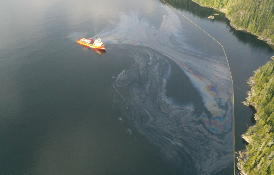
As a result of a number of sightings of sheening and oiling in the vicinity of Bligh Island / Zuciarte Channel, CCG confirms that the shipwreck of the M/V Schiedyk, a 483 ft bulk carrier that sank in 1968, has started to release oil.
The situation escalated between Dec 4-6, and heavy oil was observed on the water and staining rocks on the shoreline. As a result the Canadian Coast Guard (CCG) contracted the Western Canada Marine Response Corporation (WCMRC) to deploy to the area. CCG has established an Incident Command System (ICS) for this incident, with CCG as the Federal Incident Commander in this Unified command alongside BC Ministry of Environment and Climate Change Strategy and the Mowachaht/Muchalaht First Nation. Remotely operated vehicle (ROV) operations report that the product is seeping from more than one location and that vessel is resting hull-up in 350–400 ft (100 –120 m) of water. M/V Schiedyk was carrying approximately 1000 tons of grain and pulp when it grounded. Fuel samples have been sent to Environment and Climate Change Canada’s Pacific Environmental Science Center (PESC) and Emergencies Science and Technology Section (ESTS) laboratories from forensic chemistry and fate and behavior modeling. Oil sampling test results indicate oil is similar to historical Bunker “C” type. Rate of oil upwelling is estimated at approximately 1 – 4 L per hour, with an occasional increase to approximately 11 – 13 L per hour due to weather conditions. Daily preventative actions are being taken to contain the immediate threats and prevent long-term damage to the environment. The incident public website is updated regularly. CCG has cancelled the Transport Canada National Aerial Surveillance Program (NASP) flight tasking of the area. Overflights will be scheduled on an as-needed basis going forward. Upwelling is being monitored via Remotely Piloted Aircraft System (RPAS). Drone operations continue. Air Nootka is also conducting daily overflights. DFO’s Speed Air will also conduct overflights three times a week during the technical assessment. Large amounts off-shore boom has been placed to assist with heavy fuel oil containment. South of the wreck site deflection booming has been set up. Geographic Response Strategy (GRS) booms have been implemented across ecologically sensitive areas. DFO Marine Mammal Rescue and Focus Wildlife are on site and have been monitoring and assessing wildlife around Nootka Sound. Impacts to wildlife have been minimal to date. Resolve Marine Group, the company who is completing the Technical Assessment (TA) at the wreck site, arrived in Nootka Sound on April 18, 2021 on the vessel Atlantic Condor. |
| Incident Priorities |
|
| Agencies Involved (either in person or remote) |
|
Incident Management Team (IMT): UNIT UPDATES
OPERATIONS
Summary: In-field operations to meet incident objectives are using a combination of floating, sub-sea and aerial resources. These resources provide direction daily, and conduct assignments like Aerial Observation, Protection Booming, Wreck Assessment, surface oil collection and recovery, as well as marine mammal and wildlife assessment. Operations staff are working out of Nootka Sound and Gold River, and following integrated Safety, Communications, and Logistical plans. Planning for these tactical operations is risk-based, and determined through a planning cycle. Equipment such as storage tanks/bins, consumable like Personal Protective Equipment (PPE) and sorbents, as well as additional equipment for contingencies, are stored at the incident staging area near Gold River. Weather, remoteness, and a consistent upwelling of oil continue to challenge in-field operations.
- First concrete mattress being lowered over the rubber patch that will cover the 10m gash in the hull of the MV Schiedyk. (2021-04-26)
- On-water Ops advises they will be deploying drone at E2 as a result of them seeing oiled debris in the area (2021-04-26)
- CCG 668 is observing light sheen at their position. Sporadic, looks non-recoverable. CCG 668 also observes a log pushing up on boom inside containment at C2 and C3. WCMRC enroute. (2021-04-26)
- Shoreline patrols and high speed sweep system at the ready today. (2021-04-26)
- More Ultrasound Thickness testing was conducted overnight as well as the preparation of the hull and the tools for patch install. Installation of patch scheduled to begin around 6:45-7am this morning and last most of the day. (2021-04-26)
- Hull cleaning and UT operations are going well today and will continue into night. Resolve Marine will be ready for patch installation tomorrow and operations will start 0600-0700hrs tomorrow. It will take few hours to get down on the wreck and 4-8 hour more to secure. (2021-04-25)
- Tug W. Pearce shortening the tail between A4 anchor and shoreside Ro Boom. This will assist with keeping the Ro Boom from shifting. (2021-04-25)
- On water crews recovering minimal product with current buster. (2021-04-25)
- Small non-recoverable patches of weathered product on water being reported by CCG assets. Small weathered patches running north to south of the incident site, they are quite small and sporadic . (2021-04-25)
- Hull cleaning conducted last night and Ultrasound Thickness(UT) conducted in several areas. UT membrane being replaced for further testing. Sample also taken from main gap area. . (2021-04-25)
- Shoreline search of both Little Mooyah and South of Concepcion Point assessed negative for product. (2021-04-24)
- ROV deployed to test hull scrubbing tools, water jet, HD camera, manipulator arms and oil sampling device. ROV also has measuring tools installed to accurately measure the dimensions of the patch area on the bow section. Multiple dives today. (2021-04-24)
- RCMP vessel and crew assisting Coast Guard with enforcing Zuciarte Channel Emergency Zone over the weekend. (2021-04-24)
- Resolve ROV “As Found” video survey and sonar multibeam bathymetry survey completed overnight. (2021-04-24)
- DFO Speed Air overflight today. (2021-04-23)
- CCG deployed drifter buoy mid-Zuciarte channel. Drifter will be recovered tomorrow. (2021-04-23)
- Drone Ops observed a small amount of sheen coming off some oiled debris, north side of the containment. (2021-04-23)
- On water crews reconfigured the containment area boom to allow Resolve and the Atlantic Condor adequate room to perform the technical assessment. (2021-04-22)
- Resolve crew and Atlantic Condor’s Fast Rescue Craft (FRC) conducted additional side scan sonar at the wreck site. (2021-04-22)
- Southern Ro-Boom is now in place. (2021-04-21)
- Atlantic Condor’s FRC conducted a sonar scan of the wreck/boomed area for ghost gear at the wreck site. This is for situational awareness during ROV operations. (2021-04-21)
- An Emergency Zone has been established in Mooyah Bay for Canadian Coast Guard Environmental Response Operations. No anchoring of any vessel until further notice in Mooyah Bay. (2021-04-20)
- Resolve to perform another wet test of the ROV in a deep area from wreck site to test all components at depth. Working to connect sonar/camera components. Repairing a ground fault line in the cable to ROV. (2021-04-19)
- 4450’ of shoreline protection boom has been established from the southern Ro-Boom to the Northern Ro-Boom. (2021-04-19)
- Ewin Inlet and Little Mooyah Bay GRS in place. (2021-04-19)
- CCG operations will start a night watch shift starting tonight and will run for the duration of the technical assessment. (2021-04-19)
LOGISTICS
Summary: This incident has challenged the Incident Command Post to find innovative ways to support responders at the remote incident site while also following COVID protocols. CCG and industry have integrated to bolster the existing communication network in the area to ensure responders have a safe and dependable means to communicate with each other and the virtual Incident Command Post. By cascading private/government equipment throughout Western Canada, responders have the on-water pollution counter measure equipment required. The current lack of tourism in the area allows responders to utilize lodging that had been shut down for the off-season.
- Arranging for Coast Guard Electronics and Informatics techs to travel out to Bligh Island this week to reprogram radios, look at the communications issues at Critter Cove, and a communications issue in one of the vessels. (2021-04-26)
- 50’ section of prototype boom delivered to the Gold River staging area. (2021-04-26)
- 3500’ of 24” curtain boom and accessories was delivered to Gold River staging area over the weekend. (2021-04-24)
- Mechanic and electrician performing corrective maintenance on the Breco buoy and propane cannons. (2021-04-22)
- Continuing to procure spar buoys and lanterns so that the boomed off areas are lighted and identifiable by vessels in the area. (2021-04-19)
BOOM IN PLACE
| Coordinates | GRS Location | Length of Boom (metres) |
| 49°40.58’N, 126°28.21’W | Cheesish Reserve/Tuta Marina | 290 |
| 49°40.70’N, 126°28.59’W | Cheesish Reserve NW Bay | 801 |
| 49°40.40’N, 126°28.08’W | Cheesish Reserve SE Bay | 305 |
| 49°37.42’N, 126°31.02’W | Bligh Island Gap | 76 |
| 49°38.57’N, 126°28.70’W | Anderson Point | 137 |
| Shoreline deflection | 300 | |
| Containment North | 915 | |
| Ro-Boom South | 800 |
OIL RECOVERED
(*oil product recovered is mixed with salt water and/or organics)
| SOURCE | Amount |
| Surface Oil* | Cumulative to April 24:
36,030.975kg |
Environmental Unit (EU): UPDATES
Summary: All measures taken by the Incident Command Post utilize the Precautionary Approach and focused on minimizing damages and maximizing efforts. This approach to incident management relies on the Environmental Unit, which is comprised of Federal, Indigenous, Provincial and industry technical specialists and makes environmental-related recommendations to Unified Command that represents the interests of all contributing Environmental Unit members. An example of an ongoing agenda item for the Environmental Unit is the regular review and update of the ICS 232, a form that documents and prioritizes the Resources at Risk. Operations then use this prioritized list of environmental, economic and cultural sensitivities to build strategies and tactics to prevent damages. These proposed tactics are presented to the Unified Command for approval.
- DFO Marine Mammal team reports 20 Humpback whales spotted going in various directions southwest of Nootka Sound. (2021-04-26)
- Focus Wildlife reports no oiled wildlife observed. Monitoring efforts focused on Zuciarte Channel, the Spanish Pilot Group and the Hanna Channel. Particular focus was given to the east and west shorelines of Zuciarte Channel. Significant aggregations observed today include 200 Western Grebes dispersed south of the entrance to Zuciarte Channel. Also a raft of 10 Common Loons was observed in the Spanish Pilot Group. Observations totaled approximately 500 individuals. (2021-04-25)
- The DFO Marine Mammal Team observed more Grey Whales in Nootka Sound and less Sea Otters. With the better weather the Sea Otters may be moving to the outer coast instead of inshore waters of Nootka Sound. (2021-04-25)
- Yesterday’s drone flight saw minimal oily debris outside the Anderson Point GRS. It appeared to be around Anderson Point and into Mooyah Bay. (2021-04-25)
- 24hr oil trajectory model issued. Modeling is a prediction of oil movement on the water in the event of a larger release of oil during the Technical Assessment. Models will be provided each evening for the following morning and will help with prioritizing boom placement during the technical assessment. (2021-04-24)
- Single Grey whale spotted near Discovery Point, south Zuciarte Channel. (2021-04-24)
- Focus Wildlife observed over 400 Western Grebes in two distinct rafts in the vicinity. No oiled wildlife observed. (2021-04-24)
- No observations of oiled birds or mammals. (2021-02-23)
- Two Grey whales entering the Zuciarte Channel heading east. (2021-04-22)
- Focus 1 reports one Grey whale north of the incident site heading in an easterly direction (2021-04-21)
- On April 20, Focus Wildlife reported significant numbers of Western Grebes observed south of Bligh Island as well observed on the west side of Bligh Island. Static cannons tested. (2021-04-21)
- Whale spotted close to containment area. Focus 1 went to investigate. (2021-04-20)
- Focus Wildlife report indicates an increase in wildlife activity near the site yesterday corresponding with feed fish in the immediate area. (2021-04-20)
- It appears that the herring spawning around Nootka Sound has ended. Continue to monitor. (2021-04-19)
- Sea Otter sighted near vicinity of containment area. Focus 1 investigated. (2021-04-19)
- Whale sighted travelling south-west down eastern shorelines of Zuciarte Channel. (2021-04-19)
- Wildlife deterrence cannons remain affective around incident site. (2021-04-19)
- Small deceased fish observed in the containment area. Focus Wildlife investigated. (2021-04-19)
| Wildlife Observations | ||
| Wildlife Species | Verified Impacted (cumulative from December 10, 2020) |
Recently observed in the area near the spill site |
| Sea Otter | 1 | 95 |
| Harbour Seal | 0 | 1 |
| Stellar Sea Lion | 0 | 1 |
| Humpback | 0 | 7 |
| Orca | 0 | 10 |
| Grey whale | 0 | 12 |
| Common Murre | 1 | 1 |
| Mew Gull | 13 | 1 |
| Barrow’s Goldeneye | 0 | 11 |
| Common Merganser | 0 | 8 |
| Glaucous-winged Gull | 5 | 2 |
| Surf Scoters | 0 | 155 |
| Horned Grebe | 0 | 4 |
| Red-necked Grebe | 0 | 29 |
| Pelagic Cormorant | 0 | 2 |
| Bald Eagle | 0 | 1 |
ASSIGNED RESOURCES:
Vessels:
- Atlantic Eagle – On Water Branch Director
- CCGER 668 (PRV III)
- CCGER 735
- CCGER 750
- CCG 777
- DFO Marine Mammal Response RHIB
- WCMRC barge 200
- WCMRC Sentinel 33, Sentinel 32, Sentinel 31
- SNRC Hydra Vessel (Strategic)
- Atlantic Condor
- Tug “W. Pearce” and staging barge Miller 201 and Crane operator
- Grieg Seafood Essington II and tug AG Ford
- Tug Genni Bay and Barge Mack 8
- Focus 1
- Keystone Reservoir Dog
Equipment:
CCG:
Current Buster 2 (NOFI) – Anchored in “Helipad Bay”
Triton 20 Skimmer – on CGE 668
High Speed Sweep System
Ro-Boom: 3,200m + powerpacks
Curtain Boom: 3,950 ft
Layflat Boom (staged in Gold River): 3,500 ft
Layflat Boom (on-site pre-packed at Mooyah Bay): 4,500 ft
Breco Buoy
WCMRC:
Boom Deployed to Field: 6350 ft
- GRS: 5,350 ft
- Deflection: 1,000 ft
- Total Boom Disposed of: 2,000 ft