
Technical Assessment started at Bligh Island Shipwreck
The Technical Assessment to determine the location of and amount of fuel on board, and overall condition of the MV Schiedyk near Bligh Island has started. The MV Schiedyk sank in Nootka Sound in 1968, and started releasing oil in December, 2020. Responders operating under a Unified Command comprising of the Canadian Coast Guard, BC Ministry of Environment and Climate Change Strategy and the Mowachaht/Muchalaht First Nation. The assessment is expected to take place over two weeks, depending on weather.
During this work, Unified Command is asking boaters and others to avoid Zuciarte Channel near Bligh Island. Multiple divers, ROVs, drones and vessels will be in the area and on the water, as well as large areas boomed off as a precaution against a large release of oil from the MV Schiedyk. If boaters must transit the area, they are asked to reduce their wake to ensure the safety of the work crews.
Activities during the Technical Assessment
- Locate the leaks coming from the hull and apply temporary seals, wherever possible:
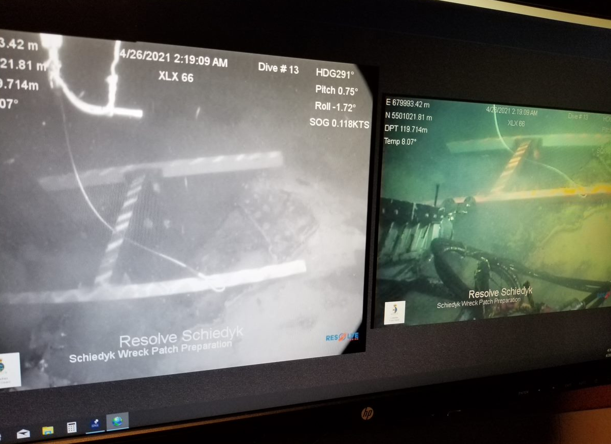
- Multi-beam sensors will be outfitted to a Remotely Operated Underwater Vessel (ROV) for high resolution images.
- Multi-beam images will be used to model the plumes of oil travelling through the water column. This data will help responders to identify the source of holes in the hull that aren’t necessarily captured by video surveys.
- Source control will be sought at the wreck site through a variety of patching methodologies using ROV and mission specific rigging and equipment.
- Survey the ship to confirm the location of fuel tanks; assess the hull, depth and position of the ship, and identify any damage as a result of the sinking in 1968:
- When the ship was converted from steam to combustion engine, it appears the tanks may have been moved from the locations shown in the original plans.
- The ROV will be used to digitally survey and map the hull of the MV Schiedyk.
- Additionally, magnetic markers will be placed along the structural boundaries of the hull. The ROV will then clean areas of the hull next to the markers, and a Cygnus Gauge will be applied to the hull to measure the thickness. The data will be used to estimate how much, if any, the steel in the hull has degraded since the ship sank.
- Confirm the existence of oil in the various tanks and map the locations:
- Reports from 1968 indicate oil was released for several weeks after the MV Schiedyk sank so Unified Command expects the Technical Assessment will provide critical information about the fuel left on board.
- The ROV will first clean the steel plating on the hull, and then Resolve Marine’s specially designed “mag drill” will make a small 5/8” hole in the suspected tank to confirm the presence of oil.
- A small sample of oil will be collected at the drill site for further analysis, and the hole will be sealed automatically, as the drill is extracted from the hole in the hull.
- Other holes may be drilled in the tank area to help determine the size of the tank or any pocket(s) of trapped oil. This information will help to inform the potential volume of oil left in the tanks.
Addressing risk during the Technical Assessment
During the technical assessment there is a small risk of disturbing the ship and causing a larger release of oil. Additionally, the configuration of boom has been moved to allow vessels and crews room to work at the shipwreck site. Unified Command is prepared for this, and has added the following resources at the shipwreck site to monitor and respond if required:
- five additional response and safety vessels at the shipwreck site
- +20 extra responders and in-field monitors
- 4,500 ft of extra boom, ready for rapid deployment
- 3,500 ft of additional boom at the staging area
- Extra supplies of PPE for responders
- Bird deterrents are in place near the containment boom and wildlife observers are on the water and actively monitoring the area during the assessment.
- The DFO Marine Mammal Team is on the water and monitoring marine mammals in the area, and
- Shoreline Clean-up Assessment Technique Teams are surveying the shoreline.
Background information:
- The shipwreck MV Schiedyk:
- A 483ft cargo ship built in Belfast, Ireland in 1948.
- On January 3, 1968 the MV Schiedyk departed Gold River with a cargo of 2,130 tons of wood pulp and 1000 tons of bulk barley on route to Portland, Oregon.
- Later that day the ship struck a submerged ledge on the south side of Bligh Island, causing extensive damage including a 100 metre gash in the hull.
- Before the 34 crew members abandoned ship, oil was reported on the water but we don’t know how much escaped at that time.
- Near midnight the ship floated off the ledge and drifted down Zuciarte Channel before grounding again on the east side of Bligh Island.
- Sonar indicates the shipwreck is in 360-400ft of water on the east side of Bligh Island.
- News coverage from 1968:
- Bligh Island is within the traditional territory of the Mowachaht/Muchalaht First Nation.
- The Bligh Island Marine Park encompasses the southern portion of Bligh Island, Villaverde Islands, Pantoja Islands, Verdia Island, Vernaci Island and Spouter Island in Nootka Sound. Bligh Island is home to mature coastal forests and within the Spanish Pilot Group of Islands, an area popular recreational destination for anglers, boaters and kayakers.
- The Incident Command System (ICS) is a process used to manage an incident with a standardized approach to the command, control and coordination of emergency response. The ICS helps responders from multiple organisations working together effectively. In the Bligh Island Shipwreck response, we are using a Unified Command to establish a common set of objectives and strategies and an Incident Action Plan.
- Response crews are following all COVID-protocols including wearing masks and other PPE, social distancing, and avoiding travel to small communities whenever possible.
- Members of the public can report oil and oiled wildlife sightings for this incident to: 1-888-801-5860
Resources for media:
Please note: due to COVID health orders issued by the Mowachaht/Muchalaht First Nation and Nuu-chah-nulth Tribal Council, and to protect the health and safety of incident response crews working at the site, media are asked to avoid travelling to the area at this time.
We regularly post information and new photos and videos to the www.SpillResponsebc.ca web site as much as possible.
Name of the ship is pronounced: shkee-dike
For more information:
Information Officer
Bligh Island Shipwreck
Email: DFO.CCGWestIMT1IOFR-OFRIEGI1OUESTGCC.MPO@dfo-mpo.gc.ca