
| SITREP | |
| Incident: | BLIGH ISLAND SHIPWRECK |
| Incident Start Date | DECEMBER 3, 2020 |
| Location: | BLIGH ISLAND, VANCOUVER ISLAND |
|
Situational Overview |
As a result of a number of sightings of sheening and oiling in the vicinity of Bligh Island / Zuciarte Channel, CCG confirms that the shipwreck of the M/V Schiedyk, a 483 ft bulk carrier that sank in 1968, has started to release oil.
The situation escalated over (Dec 4-6), and heavy oil was observed on the water and staining rocks on the shoreline. As a result the Canadian Coast Guard (CCG) contracted the Western Canada Marine Response Corporation (WCMRC) to deploy to the area. CCG has established an Incident Command System (ICS) for this incident, with CCG as the Federal Incident Commander in this Unified command alongside BC Ministry of Environment and Climate Change Strategy and the Mowachaht/Muchalaht First Nation. Remotely operated vehicle (ROV) operations report that the product is seeping from more than one location and that vessel is resting hull-up in 350–400 ft (100 –120 m) of water. M/V Schiedyk was carrying approximately 1000 tons of grain and pulp when it grounded. Fuel samples have been sent to Environment and Climate Change Canada’s Pacific Environmental Science Center (PESC) and Emergencies Science and Technology Section (ESTS) laboratories from forensic chemistry and fate and behavior modeling. Oil sampling test results indicate oil is similar to historical Bunker “C” type. Initial assessments determining the rate of oil upwelling per hour have been revised with new estimates based on waste management metrics. Rate of oil upwelling is estimated at 3 -13 L per hour, depending on weather. Please note, this is not considered an increase in upwelling but rather a more accurate estimate. Daily preventative actions are being taken to contain the immediate threats and prevent long-term damage to the environment. The incident public website is updated regularly. CCG has cancelled the Transport Canada National Aerial Surveillance Program (NASP) flight tasking of the area. Overflights will be scheduled on an as-needed basis going forward. Upwelling is being monitored via Remotely Piloted Aircraft System (RPAS). Drone operations continue. Large amounts off-shore boom has been placed to assist with heavy fuel oil containment. South of the wreck site deflection booming has been set up. Five Geographic Response Strategy (GRS) booms have been implemented across ecologically sensitive areas. DFO Marine Mammal Rescue and Focus Wildlife are on site and have been monitoring and assessing wildlife around Nootka Sound. Impacts to wildlife have been minimal to date. |
| Incident Priorities |
|
| Agencies Involved (either in person or remote) |
|
Incident Management Team (IMT): UNIT UPDATES
OPERATIONS
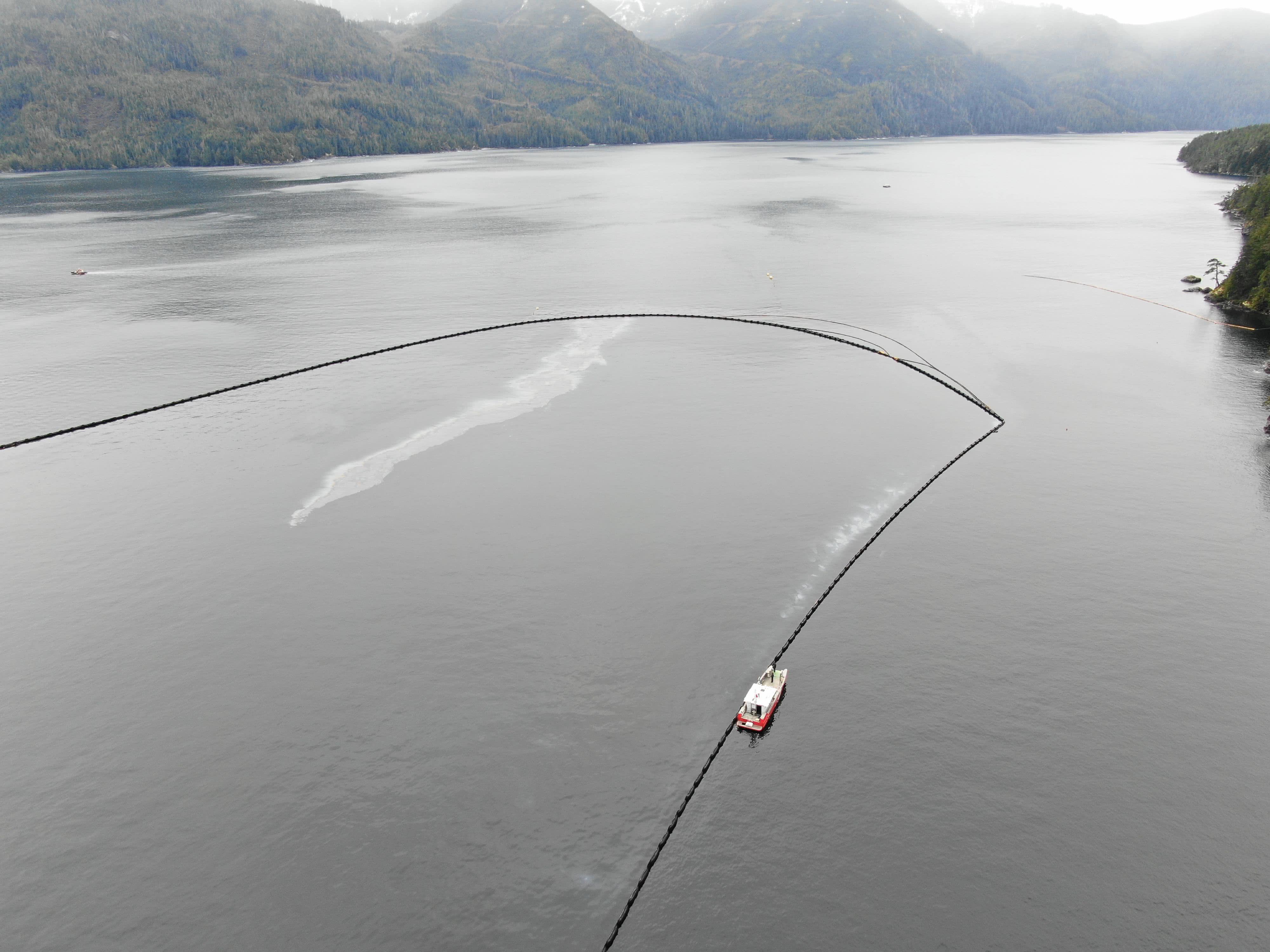
Summary: In-field operations to meet incident objectives are using a combination of floating, sub-sea and aerial resources. These resources provide direction daily, and conduct assignments like Aerial Observation, Protection Booming, Wreck Assessment, surface oil collection and recovery, as well as marine mammal and wildlife assessment. Operations staff are working out of Nootka Sound and Gold River, and following integrated Safety, Communications, and Logistical plans. Planning for these tactical operations is risk-based, and determined through a planning cycle. Equipment such as storage tanks/bins, consumable like Personal Protective Equipment (PPE) and sorbents, as well as additional equipment for contingencies, are stored at the incident staging area near Gold River. Weather, remoteness, and a consistent upwelling of oil continue to challenge in-field operations.
- Assessed reports of potential marine pollution at Yuquot. CGE 668 investigated and reported no sheening in the area. (2021-03-13)
- CGE 668 towed derelict “barge” out of Muchalaht Inlet to shore. (2021-03-13)
- Remotely Operated Vehicle (ROV) dive team to check moorings. (2021-03-12)
- Unmanned Aerial Vehicle (UAV) flying to map and measure possible boom configurations. (2021-03-12)
- Northeast mooring repair completed successfully. (2021-03-11)
- Ro-boom bladder deflated and being repaired. (2021-03-11)
- WCMRC towed High Speed Sweep to barge for investigation of underwater pocket which didn’t fully open. (2021-03-10)
- 2500 ft of high floatation boom enroute to Gold River. (2021-03-08)
- Log Boom contractor back on-site making repairs to boom arrangement. (2021-03-08)
- Divers working east Zuciarte Channel opposite of “The Cutt”. (2021-03-08)
LOGISTICS
Summary: This incident has challenged the Incident Command Post to find innovative ways to support responders at the remote incident site while also following COVID protocols. CCG and industry have integrated to bolster the existing communication network in the area to ensure responders have a safe and dependable means to communicate with each other and the virtual Incident Command Post. By cascading private/government equipment throughout Western Canada, responders have the on-water pollution counter measure equipment required. The current lack of tourism in the area allows responders to utilize lodging that had been shut down for the off-season.
- Second Britco office has arrived at the Staging Area. (2021-03-12)
- Ensured trucks are ready to roll for crew change Monday. (2021-03-12)
- New Britco office has been installed at Staging Area. (2021-03-11)
- Made contact with AG Ford to repair mooring lines. ETA Thursday morning to begin work. (2021-03-09)
- Bird deterrent devices are enroute to Gold River. (2021-03-09)
BOOM IN PLACE
| Coordinates | GRS Location | Length of Boom (feet) | Length of Boom (metres) |
| 49°40.58’N, 126°28.21’W | Cheesish Reserve/Tuta Marina | 950 | 290 |
| 49°40.70’N, 126°28.59’W | Cheesish Reserve NW Bay | 2450 | 747 |
| 49°40.40’N, 126°28.08’W | Cheesish Reserve SE Bay | 1000 | 305 |
| 49°37.42’N, 126°31.02’W | Bligh Island Gap | 550 | 168 |
| 49°38.57’N, 126°28.70’W | Anderson Point | 400 | 122 |
| Total Deployed | 5350 | 1632 |
OIL RECOVERED
(oil product recovered is mixed with salt water and/or organics)
| SOURCE | Amount |
| Surface Oil | Cumulative to March 13: 30,436.6 kg (2021-03-13) Note: a crane operated from the staging barge is providing measurements of oil and oily debris recovered by weight. Number of bags/super sacks will no longer be used. |
Environmental Unit (EU): UPDATES
Summary: All measures taken by the Incident Command Post utilize the Precautionary Approach and focused on minimizing damages and maximizing efforts. This approach to incident management relies on the Environmental Unit, which is comprised of Federal, Indigenous, Provincial and industry technical specialists and makes environmental-related recommendations to Unified Command that represents the interests of all contributing Environmental Unit members. An example of an ongoing agenda item for the Environmental Unit is the regular review and update of the ICS 232, a form that documents and prioritizes the Resources at Risk. Operations then use this prioritized list of environmental, economic and cultural sensitivities to build strategies and tactics to prevent damages. These proposed tactics are presented to the Unified Command for approval.
- Pacific herring have been gathering in the outside areas of Nootka Sound. A test vessel estimated 10,000 tons on March 7, 2021. Some limited spawning has been observed in areas just outside Nootka Sound as well as in both Clayoquot Sound to the south, and Esperanza Inlet to the north. Indications are that spawning closer to the incident site may begin anytime, but likely in the next 1-2 weeks. (2021-03-12)
- On March 11, Focus Wildlife conducted surveys from Yuquot west towards Bajo Point and Skuna Bay. The crew observed various species of wildlife along western span of shoreline. No herring spawn was observed but this type of large bird aggregation is consistent with the likelihood of fish present in the area. (2021-03-12)
- Two wolves were also observed scavenging on a sea lion carcass on a shoreline. (2021-03-12)
- Two new slightly oiled birds were detected yesterday, bringing the total up to 18. (2021-03-11)
- One oiled adult Mew Gull was observed on March 6, and one oiled juvenile Glaucous-winged Gull was observed on March 8. This brings the total number of confirmed oiled birds to-date to 16. (2021-03-10)
- Focus Wildlife continues to conduct deterrence activities near the Ro-boom as well as ongoing monitoring around Bligh Island. (2021-03-10)
- Boat reconnaissance surveys took place in Ewin Inlet, the Spanish Pilot Group, eastern Zuciarte Channel and Mooyah Bay. A group of 85 surf scoters was observed in the Ewin Inlet area. (2021-03-10)
- All sample sediments that were taken for sampling were below 20 parts per billion (ppb) limit. (2021-03-08)
- Focus Wildlife testing bird deterrents. (2021-03-08)
- Abalone Survey Dives complete and will continue with lab analysis. (2021-03-08)
- Second round of SCAT photo monitoring complete. Next window of opportunity begins March 16. (2021-03-08)
| Wildlife Observations (cumulative from December 10, 2020)
|
||
| Wildlife Species | Verified Impacted | Observed in the area near the spill site |
| Sea Otter | 1 | 95 |
| Harbour Seal | 1 | |
| Stellar Sea Lion | 1 | |
| Baleen Whale | 6 Humpbacks | |
| Orca | 10 | |
| Grey whale | 4 | |
| Blue Heron | 1 | |
| Common Murrelet | 1 | |
| Marbled Murrelet | 4 | |
| Mew Gull | 12 | 16 |
| Barrow’s Goldeneye | 12 | |
| Glaucous-winged Gull | 5 | 16 |
| Gulls (mixed species) | 350 | |
| Cormorant | 700 | |
| Bald Eagle | 60 | |
| Wolf | 2 | |
ASSIGNED RESOURCES:
Vessels:
- Atlantic Raven – On Water Branch Director
- CCGS Moorhen (RHIB)
- CCG 750 (PRV III)
- CCG 668 (PRV III)
- DFO Vessel “Marine Mammal Response”
- WCMRC – Sentinel 33
- WCMRC barge 200
- SNRC Hydra Vessel (Strategic)
- Grieg Seafood Contracted Vessel “Essington II” and assist Tug “AG Ford”
- Focus Wildlife “Focus 1”
- Tug “W. Pearce” and staging barge Miller 201 and Crane operator
- Cypress Creek Logging
- Sand Buoy Chief
Equipment:
CCG:
Current Buster 2 (NOFI) – Anchored in “Helipad Bay”
Triton 20 Skimmer – on CGE 668
RoBoom: 3300 ft
Curtain Boom 1200 ft
WCMRC:
Boom Deployed to Field: 6,350 ft
- GRS: 5,350 ft
- Deflection: 1000 ft
- Total Boom Disposed of: 2,000 ft