
| SITREP | |
| Incident: | BLIGH ISLAND SHIPWRECK |
| Incident Start Date | DECEMBER 3, 2020 |
| Location: | BLIGH ISLAND, VANCOUVER ISLAND |
| Situational Overview | As a result of a number of sightings of sheening and oiling in the vicinity of Bligh Island / Zuciarte Channel, CCG confirms that the shipwreck of the M/V Schiedyk, a 483 ft bulk carrier that sank in 1968, has started to release oil. The situation escalated over (Dec 4-6), and heavy oil was observed on the water and staining rocks on the shoreline. As a result the Canadian Coast Guard (CCG) contracted the Western Canada Marine Response Corporation (WCMRC) to deploy to the area. CCG has established an Incident Command System (ICS) for this incident, with CCG as the Federal Incident Commander in this Unified command alongside Ministry of Environment and Climate Change Strategy and the Mowachaht/Muchalaht First Nation. Remotely operated vehicle (ROV) operations report that the product is seeping from more than one location and that vessel is resting hull-up in 350–400 ft (100 –120 m) of water. M/V Schiedyk was carrying approximately 1000 tons of grain and pulp when it grounded. Fuel samples have been sent to Environment and Climate Change Canada’s Pacific Environmental Science Center (PESC) and Emergencies Science and Technology Section (ESTS) laboratories from forensic chemistry and fate and behavior modeling. Oil sampling test results indicate oil is similar to historical Bunker “C” type. Initial assessments determining the rate of oil upwelling per hour have been revised with new estimates based on waste management metrics. Rate of oil upwelling is estimated at 3 -13 L per hour, depending on weather. Please note, this is not considered an increase in upwelling but rather a more accurate estimate. Daily preventative actions are being taken to contain the immediate threats and prevent long-term damage to the environment. The incident public website is updated regularly. CCG has cancelled the Transport Canada National Aerial Surveillance Program (NASP) flight tasking of the area. Overflights will be scheduled on an as-needed basis going forward. Upwelling is being monitored via Remotely Piloted Aircraft System (RPAS). Drone operations continue. Large amount off-shore boom has been placed to assist with heavy fuel oil containment. South of the wreck site deflection booming has been set up. Five Geographic Response Strategy (GRS) booms have been implemented across ecologically sensitive areas. DFO Marine Mammal Rescue and Focus Wildlife are on site and have been monitoring and assessing wildlife around Nootka Sound. Impacts to wildlife have been minimal to date. Two shoreline Clean-up Assessment Teams (SCAT) were deployed and have surveyed 100km of shoreline near the wreck site. A photo monitoring program is being conducted. |
| Incident Priorities | · Maximize response staff integration across organizations.
· Ensure safety of responders and the public. · Ensure a unified response effort to include Federal, Provincial, and Indigenous priorities. · Minimize impacts to ecological, socio-economic, and cultural areas. · Ensure fluid and efficient incident communication is easily accessible. · Ensure efficiency in marine operations. |
| Agencies Involved (either in person or remote) | · Unified Command – Canadian Coast Guard, Mowachaht/Muchalaht First Nation, BC Ministry of Environment and Climate Change Strategy
· Canadian Coast Guard · National Environmental Emergencies Centre, Environment and Climate Change Canada · BC Ministry of Environment and Climate Change Strategy · Western Canada Marine Response Corporation · Ehattesaht Fisheries · Nuu Chah Nulth Tribal Council · Mowachaht/Muchalaht First Nation · Hesquiaht First Nation · BC Parks · Fisheries and Oceans Canada · Canadian Wildlife Service · Grieg Seafood |
Incident Management Team (IMT): UNIT UPDATES
OPERATIONS
Summary: In-field operations to meet incident objectives are using a combination of floating, sub-sea and aerial resources. These resources provide direction daily, and conduct assignments like Aerial Observation, Protection Booming, Wreck Assessment, surface oil collection and recovery, as well as marine mammal and wildlife assessment. Operations staff are working out of Nootka Sound and Gold River, and following integrated Safety, Communications, and Logistical plans. Planning for these tactical operations is risk-based, and determined through a planning cycle. Equipment such as storage tanks/bins, consumable like Personal Protective Equipment (PPE) and sorbents, as well as additional equipment for contingencies, are stored at the incident staging area near Gold River. Weather, remoteness, and a consistent upwelling of oil continue to challenge in-field operations.
- CCG 750 conducted an ROV dive on the northwest side of wreck. (2021-03-07)
- CCG 750, CCG 668 and WCMRC Hydra (doing trials) on water, working on marking the boom sticks with lights. One light is rigged and another buoy and light installed today. (2021-03-07)
- Spar buoys deployed to hold lights along boom sticks. (2021-03-06)
- Moorhen undergoing repairs, CCGE 750 assumed Safety duties. (2021-03-06)
- On-water Ops cancelled due to weather. (2021-03-05)
- CCG 688 transferring cargo from barge to staging. (2021-03-04)
- Monitoring Brooks Buoy data in order to predict northward drift and increased upwelling. (2021-03-04)
- WCMRC adding secondary boom to Northern Apex. (2021-03-04)
- NASP Tasking has been cancelled and will require more diligence from our Remotely Piloted Aircraft System (RPAS) crews going forward. (2021-03-03)
LOGISTICS
Summary: This incident has challenged the Incident Command Post to find innovative ways to support responders at the remote incident site while also following COVID protocols. CCG and industry have integrated to bolster the existing communication network in the area to ensure responders have a safe and dependable means to communicate with each other and the virtual Incident Command Post. By cascading private/government equipment throughout Western Canada, responders have the on-water pollution counter measure equipment required. The current lack of tourism in the area allows responders to utilize lodging that had been shut down for the off-season.
- Light reference added to NAVWARN. (2021-03-07)
- Confirming spar buoy coordinates to issue NAVWARN. (2021-03-06)
- Logistics has shipped sorbent boom and supplies to Gold River. (2021-03-05)
- Organized shipment of Curtain boom from Port Hardy to Gold River on Monday. (2021-03-05)
- Setting up a standing offer for tug and barge services to help with boom anchors / deployment, etc. (2021-03-03)
AIR OPERATIONS
Summary: Weather within the steep mountains that surround Nootka Sound continue to challenge aerial observations. The incident is using both fixed and rotary wing manned aircraft to provide real-time observations to ground crews on an as-needed basis. Transport Canada’s National Aerial Surveillance Program (NASP) is able to quantify and outline the on-water oil. This information is then used to support recovery operations and future trajectory modelling. In addition to manned aircraft, Remotely Piloted Aircraft System (RPAS) teams from CCG and industry remain on scene to support individual task forces.
- NASP Taskings have ended. NASP will do overflights on an as needed basis. (2021-03-04)
- No NASP flight today. (2021-03-02 to 2021-03-03)
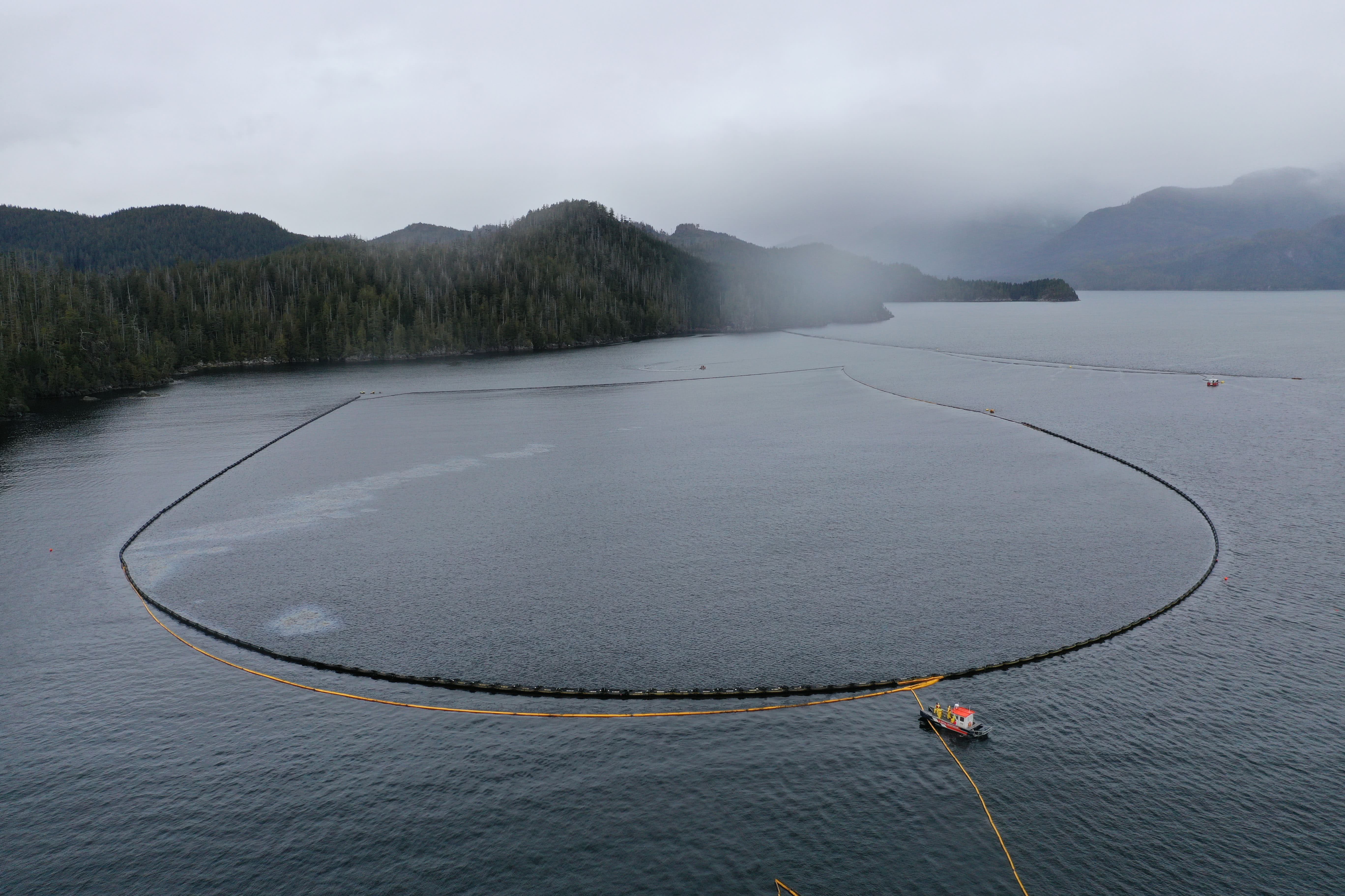
BOOM IN PLACE
| Coordinates | GRS Location | Length of Boom (feet) | Length of Boom (metres) |
| 49°40.58’N, 126°28.21’W | Cheesish Reserve/Tuta Marina | 950 | 290 |
| 49°40.70’N, 126°28.59’W | Cheesish Reserve NW Bay | 2450 | 747 |
| 49°40.40’N, 126°28.08’W | Cheesish Reserve SE Bay | 1000 | 305 |
| 49°37.42’N, 126°31.02’W | Bligh Island Gap | 550 | 168 |
| 49°38.57’N, 126°28.70’W | Anderson Point | 400 | 122 |
| Total Deployed | 5350 | 1632 |
OIL RECOVERED
(oil product recovered is mixed with salt water and/or organics)
| SOURCE | Amount |
| Surface Oil | Cumulative to March 8: 28,669.91kg (2021-03-05)
Note: a crane operated from the staging barge is providing measurements of oil and oily debris recovered by weight. Number of bags/super sacks will no longer be used. |
Environmental Unit (EU): UPDATES
Summary: All measures taken by the Incident Command Post utilize the Precautionary Approach and focused on minimizing damages and maximizing efforts. This approach to incident management relies on the Environmental Unit, which is comprised of Federal, Indigenous, Provincial and industry technical specialists and makes environmental-related recommendations to Unified Command that represents the interests of all contributing Environmental Unit members. An example of an ongoing agenda item for the Environmental Unit is the regular review and update of the ICS 232, a form that documents and prioritizes the Resources at Risk. Operations then use this prioritized list of environmental, economic and cultural sensitivities to build strategies and tactics to prevent damages. These proposed tactics are presented to the Unified Command for approval.
- No significant updates today. (2021-03-05 to 2021-03-07)
- Working on Wildlife Transition Plan. (2021-03-04)
- Submit preliminary endpoints/treatment targets document. (2021-03-04)
- Focus Wildlife Auditory Static Deterrence and Daily Field Reports have been compiled. (2021-03-02)
| Wildlife Observations (cumulative from December 10, 2020) | ||
| Wildlife Species | Verified Impacted | Observed in the area near the spill site |
| Sea Otter | 1 | 95 |
| Harbour Seal | 1 | |
| Stellar Sea Lion | 1 | |
| Baleen Whale | 6 Humpbacks | |
| Orca | 10 | |
| Blue Heron | 1 | |
| Common Murre | 1 | |
| Marbled Murrelet | 4 | |
| Mew Gull | 9 | 16 |
| Barrow’s Goldeneye | 12 | |
| Glaucous-winged Gull | 4 | 16 |
| Gulls (mixed species) | 350 | |
ASSIGNED RESOURCES:
Vessels:
- CCGS Tanu – On Water Branch Director
- CCGS Moorhen (RHIB)
- CCG 750 (PRV III)
- CCG 668 (PRV III)
- DFO Vessel “Marine Mammal Response”
- WCMRC – Sentinel 33
- SNRC Hydra Vessel (Strategic)
- Grieg Seafood Contracted Vessel and assist Tug “Nelson Mac”
- Focus Wildlife “Focus 1”
- Tug “W. Pearce” and staging barge Miller 201 and Crane operator
- Gold River Timber “Hooktender”
Equipment:
CCG:
Current Buster 2 (NOFI) – Anchored in “Helipad Bay”
Triton 20 Skimmer – on CGE 668
RoBoom: 3300 ft
Curtain Boom 1200 ft
WCRMC:
Boom Deployed to Field: 6350 ft
- GRS: 5350 ft
- Deflection: 1000 ft
- Total Boom Disposed of: 2000 ft