
| SITREP | |
| Incident: | BLIGH ISLAND SHIPWRECK |
| Incident Start Date | DECEMBER 3, 2020 |
| Location: | BLIGH ISLAND, VANCOUVER ISLAND |
|
Situational Overview |
As a result of a number of sightings of sheening and oiling in the vicinity of Bligh Island / Zuciarte Channel, CCG confirms that the shipwreck of the M/V Schiedyk, a 483 ft bulk carrier that sank in 1968, has started to release oil.
The situation escalated over (Dec 4-6), and heavy oil was observed on the water and staining rocks on the shoreline. As a result the Canadian Coast Guard (CCG) contracted the Western Canada Marine Response Corporation (WCMRC) to deploy to the area. CCG has established an Incident Command System (ICS) for this incident, with CCG as the Federal Incident Commander in this Unified command alongside Ministry of Environment and Climate Change Strategy and the Mowachaht/Muchalaht First Nation. Remotely operated vehicle (ROV) operations report that the product is seeping from more than one location and that vessel is resting hull-up in 350–400 ft (100 –120 m) of water. M/V Schiedyk was carrying approximately 1000 tons of grain and pulp when it grounded. Fuel samples have been sent to Environment and Climate Change Canada’s Pacific Environmental Science Center (PESC) and Emergencies Science and Technology Section (ESTS) laboratories from forensic chemistry and fate and behavior modeling. Oil sampling test results indicate oil is similar to historical Bunker “C” type. Initial assessments determining the rate of oil upwelling per hour have been revised with new estimates based on waste management metrics. Rate of oil upwelling is estimated at 3 -13 L per hour, depending on weather. Please note, this is not considered an increase in upwelling but rather a more accurate estimate.
Daily preventative actions are being taken to contain the immediate threats and prevent long-term damage to the environment. The incident public website is updated regularly. CCG has on going scheduled Transport Canada National Aerial Surveillance Program (NASP) over flights of the area. Drone operations continue. Large amount off-shore boom has been placed to assist with heavy fuel oil containment. South of the wreck site deflection booming has been set up. Five Geographic Response Strategy (GRS) booms have been implemented across ecologically sensitive areas. DFO Marine Mammal Rescue and Focus Wildlife are on site and have been monitoring and assessing wildlife around Nootka Sound. Impacts to wildlife have been minimal to date. Two Shoreline Clean-up Assessment Teams (SCAT) were deployed and have surveyed 100km of shoreline near the wreck site. A photo monitoring program is being conducted. |
| Incident Priorities |
|
| Agencies Involved (either in person or remote) |
|
Incident Management Team (IMT): UNIT UPDATES
OPERATIONS
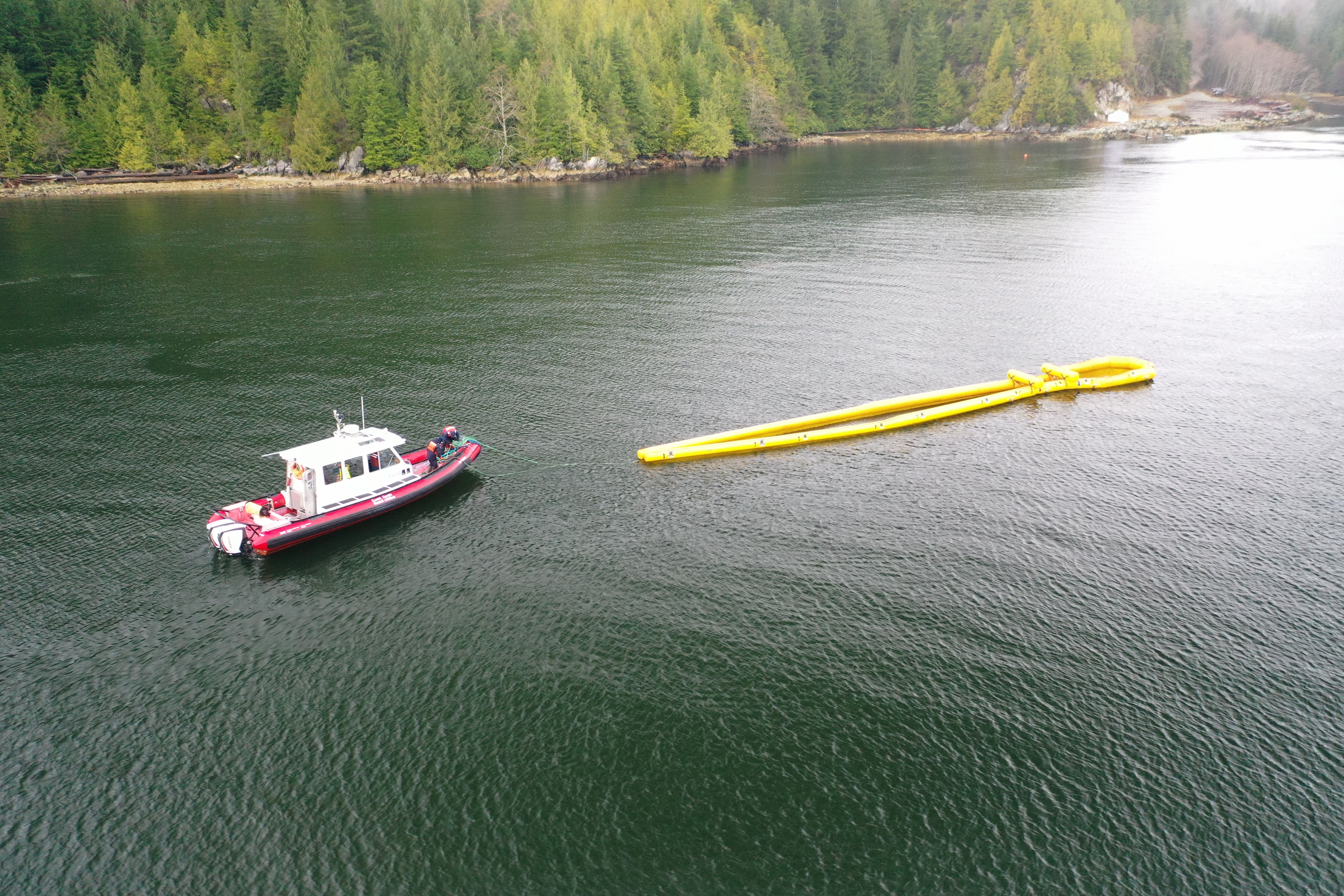
Summary: In-field operations to meet incident objectives are using a combination of floating, sub-sea and aerial resources. These resources provide direction daily, and conduct assignments like Aerial Observation, Protection Booming, Wreck Assessment, surface oil collection and recovery, as well as marine mammal and wildlife assessment. Operations staff are working out of Nootka Sound and Gold River, and following integrated Safety, Communications, and Logistical plans. Planning for these tactical operations is risk-based, and determined through a planning cycle. Equipment such as storage tanks/bins, consumable like Personal Protective Equipment (PPE) and sorbents, as well as additional equipment for contingencies, are stored at the incident staging area near Gold River. Weather, remoteness, and a consistent upwelling of oil continue to challenge in-field operations.
- Oil collection will be done by the Hydra today. (2021-03-01)
- Atlantic Raven hands over On Water Branch Director to CCGS Tanu (2021-02-28)
- Three one-ton weights brought and 2,400 ft of galvanized cable brought to the barge by the Pollution Response Vessels (PRV) for upcoming boom stick repair/replacement (2021-02-28)
- Drone flight observed more product in the pocket today with a small amount of entrainment (2021-02-28)
- Replaced a section of torn boom on the north section of the containment (2021-02-28)
- More product observed in the northern part of the containment area than previously seen (2021-02-27)
- High currents (likely tide related) were seen that caused a pull on the anchor line resulting in entrainment; currents were seen to subside and entrainment stopped (2021-02-27)
- Secondary containment was lined with sorbet boom for recovery (2021-02-27)
- Staging area tested the degreaser today with great results: Highly effective, quick acting and low odour. (2021-02-26)
- Crews will add sorbent socks between the general purpose boom and Ro Boom overlapping sections at the north end of the containment area to help minimize any product escapement when upwelling shifts to the north. (2021-02-24)
- A report of a small amount of product just outside the containment boom to the north. Nothing seen in the vicinity of the fish farms. (2021-02-23)
- Daily assessment of Ro Boom. Also, Geographic Response Strategies (GRS) checks and adjustments as required. (2021-02-23)
- All vessels stood down early due to weather. No drone operations today due to weather. (2021-02-21)
- Damaged RoBoom section has been temporarily repaired. (2021-02-20)
LOGISTICS
Summary: This incident has challenged the Incident Command Post to find innovative ways to support responders at the remote incident site while also following COVID protocols. CCG and industry have integrated to bolster the existing communication network in the area to ensure responders have a safe and dependable means to communicate with each other and the virtual Incident Command Post. By cascading private/government equipment throughout Western Canada, responders have the on-water pollution counter measure equipment required. The current lack of tourism in the area allows responders to utilize lodging that had been shut down for the off-season.
- Ten Zello accounts have been activated for Incident Command Post (ICP) personnel. This will allow ICP to hear communications at incident site improving situational awareness. (2021-02-24)
- VHF repeater is now functional again. Problem has been identified and plans are in place to keep it operational moving forward. (2021-02-24)
- Coast Guard technicians working on VHF repeater. (2021-02-23)
AIR OPERATIONS
Summary: Weather within the steep mountains that surround Nootka Sound continue to challenge aerial observations. The incident is using both fixed and rotary wing manned aircraft to provide real-time observations to ground crews. Transport Canada’s National Aerial Surveillance Program (NASP) is able to quantify and outline the on-water oil. This information is then used to support recovery operations and future trajectory modelling. In addition to manned aircraft, Remotely Piloted Aircraft System (RPAS) teams from CCG and industry remain on scene to support individual task forces.
- Drone ops will be conducted in the vicinity of the wreck site and the two fish farms NE of main containment boom today. (2021-03-01)
- No NASP overflights. (2021-02-25 – 2021-02-28)
- NASP overflight indicated approx. 2.5L of product on the surface, all within the containment boom. (2021-02-24)
- CCG Helicopter and CCG tech crew were not able to make repairs to the repeater yesterday due to weather. Helicopter and crew stayed in Gold River overnight. Attempting repairs today. (2021-02-23)
- NASP overflight shows 6.5L of oil on the water, all contained within the containment boom at wreck site. (2021-02-22)
- CCG helicopter 435 tasked to the incident repeater site for repairs. (2021-02-22)
- No NASP overflights this weekend. (2021-02-21)
BOOM IN PLACE
| Coordinates | GRS Location | Length of Boom (feet) | Length of Boom (metres) |
| 49°40.58’N, 126°28.21’W | Cheesish Reserve/Tuta Marina | 950 | 290 |
| 49°40.70’N, 126°28.59’W | Cheesish Reserve NW Bay | 2450 | 747 |
| 49°40.40’N, 126°28.08’W | Cheesish Reserve SE Bay | 1000 | 305 |
| 49°37.42’N, 126°31.02’W | Bligh Island Gap | 550 | 168 |
| 49°38.57’N, 126°28.70’W | Anderson Point | 400 | 122 |
| Total Deployed | 5350 | 1632 |
OIL RECOVERED
(oil product recovered is mixed with salt water and/or organics)
| SOURCE | Amount |
| Surface Oil | Cumulative to March 1: 28,085kg (2021-03-01) Note: a crane operated from the staging barge is providing measurements of oil and oily debris recovered by weight. Number of bags/super sacks will no longer be used. |
Environmental Unit (EU): UPDATES
Summary: All measures taken by the Incident Command Post utilize the Precautionary Approach and focused on minimizing damages and maximizing efforts. This approach to incident management relies on the Environmental Unit, which is comprised of Federal, Indigenous, Provincial and industry technical specialists and makes environmental-related recommendations to Unified Command that represents the interests of all contributing Environmental Unit members. An example of an ongoing agenda item for the Environmental Unit is the regular review and update of the ICS 232, a form that documents and prioritizes the Resources at Risk. Operations then use this prioritized list of environmental, economic and cultural sensitivities to build strategies and tactics to prevent damages. These proposed tactics are presented to the Unified Command for approval.
- Oiled tree branches at the splash or supratidal zone were observed along the shoreline (2021-02-28)
- Overflights have begun monitoring the west coast of Vancouver Island for signs of herring spawning activity (e.g. aqua-blue coloration in the water). Pacific herring will spawn in the Nootka Sound area in March and April; the response will likely see increased wildlife (bird and marine mammal) activity in the area. (2021-02-26)
- Bird deterrence cannons used at wreck site. (2021-02-26)
- On February 23, two new Mew Gulls were oiled. Deterrence activity continues to be effective at keeping birds away from the casualty site. (2021-02-24)
- Feedback from the Focus Wildlife field crew is that regular and ongoing deterrence is an effective strategy in ensuring the containment area is less desirable for feeding. (2020-02-22)
- Recent reviews of the Resources at Risk and associated priority rankings within geographic subsets of sites have integrated bird observation data collected by Focus Wildlife over January and February and have been very informative in evaluating biological concerns amongst priority sites. (2020-02-22)
- Similar Mew Gull (15 birds) and Marbled Murrelet (4) activity was observed near the Ro-boom on February 20 and were deterred again. The outer containment boom continues to be an area used by birds for perching. (2020-02-20)
| Wildlife Observations (cumulative from December 10, 2020) | ||
| Wildlife Species | Verified Impacted | Observed in the area near the spill site |
| Sea Otter | 1 | 95 |
| Harbour Seal | 1 | |
| Stellar Sea Lion | 1 | |
| Baleen Whale | 6 Humpbacks | |
| Orca | 10 | |
| Blue Heron | 1 | |
| Common Murre | 1 | |
| Marbled Murrelet | 4 | |
| Mew Gull | 9 | 16 |
| Barrow’s Goldeneye | 12 | |
| Glaucous-winged Gull | 4 | 16 |
| Gulls (mixed species) | 350 | |
ASSIGNED RESOURCES:
Vessels:
- CCGS Tanu – On Water Branch Director
- CCGS Moorhen (RHIB)
- CCG 750 (PRV III)
- CCG 668 (PRV III)
- DFO Vessel “Marine Mammal Response”
- WCMRC – Sentinel 33
- SNRC Hydra Vessel (Strategic)
- Grieg Seafood Contracted Vessel and assist Tug “Nelson Mac”
- Focus Wildlife “Focus 1”
- Tug “W. Pearce” and staging barge Miller 201 and Crane operator
- Gold River Timber “Hooktender”
Equipment:
CCG:
Current Buster 2 (NOFI) – Anchored in “Helipad Bay”
Triton 20 Skimmer – on CGE 668
RoBoom: 3300 ft
GP Boom 1200 ft
WCRMC:
Boom Deployed to Field: 6350 ft
- GRS: 5350 ft
- Deflection: 1000 ft
Total Boom Disposed of: 2