
| Incident: | BLIGH ISLAND SHIPWRECK |
| Incident Start Date | DECEMBER 3, 2020 |
| Location: | BLIGH ISLAND, VANCOUVER ISLAND |
|
Situational Overview |
As a result of a number of sightings of sheening and oiling in the vicinity of Bligh Island / Zuciarte Channel, CCG confirms that the shipwreck of the M/V Schiedyk, a 483 ft bulk carrier that sank in 1968, has started to release oil.
The situation escalated over (Dec 4-6), and heavy oil was observed on the water and staining rocks on the shoreline. As a result the Canadian Coast Guard (CCG) contracted the Western Canada Marine Response Corporation (WCMRC) to deploy to the area. CCG has established an Incident Command System (ICS) for this incident, with CCG as the Federal Incident Commander in this Unified command alongside Ministry of Environment and Climate Change Strategy and the Mowachaht/Muchalaht First Nation. Remotely operated vehicle (ROV) operations report that the product is seeping from more than one location and that vessel is resting hull-up in 350–400 ft (100 –120 m) of water. M/V Schiedyk was carrying approximately 1000 tons of grain and pulp when it grounded. Fuel samples have been sent to Environment and Climate Change Canada’s Pacific Environmental Science Center (PESC) and Emergencies Science and Technology Section (ESTS) laboratories from forensic chemistry and fate and behavior modeling. Oil sampling test results indicate oil is similar to historical Bunker “C” type. Initial assessments determining the rate of oil upwelling per hour have been revised with new estimates based on waste management metrics. Rate of oil upwelling is estimated at 3 -13 L per hour, depending on weather. Please note, this is not considered an increase in upwelling but rather a more accurate estimate.
Daily preventative actions are being taken to contain the immediate threats and prevent long-term damage to the environment. The incident public website is updated regularly. CCG has on going scheduled Transport Canada National Aerial Surveillance Program (NASP) over flights of the area. Drone operations continue. Large amount off-shore boom has been placed to assist with heavy fuel oil containment. South of the wreck site deflection booming has been set up. Five Geographic Response Strategy (GRS) booms have been implemented across ecologically sensitive areas. DFO Marine Mammal Rescue and Focus Wildlife are on site and have been monitoring and assessing wildlife around Nootka Sound. Impacts to wildlife have been minimal to date. Two Shoreline Clean-up Assessment Teams (SCAT) were deployed and have surveyed 100km of shoreline near the wreck site. A photo monitoring program is set to begin mid February. |
| Incident Priorities |
|
| Agencies Involved (either in person or remote) |
|
Incident Management Team (IMT): UNIT UPDATES
OPERATIONS
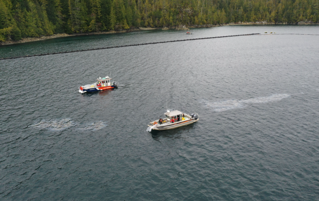
Summary: In-field operations to meet incident objectives are using a combination of floating, sub-sea and aerial resources. These resources provide direction daily, and conduct assignments like Aerial Observation, Protection Booming, Wreck Assessment, surface oil collection and recovery, as well as marine mammal and wildlife assessment. Operations staff are working out of Nootka Sound and Gold River, and following integrated Safety, Communications, and Logistical plans. Planning for these tactical operations is risk-based, and determined through a planning cycle. Equipment such as storage tanks/bins, consumable like Personal Protective Equipment (PPE) and sorbents, as well as additional equipment for contingencies, are stored at the incident staging area near Gold River. Weather, remoteness, and a consistent upwelling of oil continue to challenge in-field operations.
- No pollution recovery at the wreck site today due to low amount of product in the containment area. (2021-02-19)
- Focus Wildlife surveying from Concepcion Fish Pen to Bligh Island Cut. (2021-02-18)
- Product recovery continues at the wreck site. (2021-02-18)
- Cannon blast deterrence used for birds at wreck site. (2021-02-18)
- Geographic Response Strategies (GRS) inspections and debris maintenance continues. (2021-02-18)
- Crews did not observe enough product in the containment boom to collect today. (2021-02-17)
- Crews working around the containment boom noticed the product was heading in a northerly direction in the afternoon. No observations of product escaping the containment. (2021-02-16)
- On water crews tended to containment boom and replaced (4) chains on the boom sticks. (2021-02-16)
- Indigenous Community Response Team on site today touring the incident. (2021-02-16)
- Shoreline Clean-up Assessment Teams (SCAT) back on water conducting photo monitoring operations. (2021-02-16)
- CCGER 668 crew fixing and replacing boom chains at the wreck site as required. (2021-02-16)
- Product recovery in the containment boom. (2021-02-16)
LOGISTICS
Summary: This incident has challenged the Incident Command Post to find innovative ways to support responders at the remote incident site while also following COVID protocols. CCG and industry have integrated to bolster the existing communication network in the area to ensure responders have a safe and dependable means to communicate with each other and the virtual Incident Command Post. By cascading private/government equipment throughout Western Canada, responders have the on-water pollution counter measure equipment required. The current lack of tourism in the area allows responders to utilize lodging that had been shut down for the off-season.
- Considerations for decontamination plan have been received and sent to the OSC for review. (2021-02-19)
- VHF repeater is still down due to snow. 82A comms remain poor around incident. (2021-02-19)
- Spar buoys have arrived at the wreck site. Lights for the buoys have been ordered and should arrive early next week. (2021-02-18)
- Berm has been purchased. Team continues to work on purchasing equipment for the decontamination plan. (2021-02-16)
- Personal Protective Equipment (PPE) bulk order is starting to be filled. (2021-02-16)
AIR OPERATIONS
Summary: Weather within the steep mountains that surround Nootka Sound continue to challenge aerial observations. The incident is using both fixed and rotary wing manned aircraft to provide real-time observations to ground crews. Transport Canada’s National Aerial Surveillance Program (NASP) is able to quantify and outline the on-water oil. This information is then used to support recovery operations and future trajectory modelling. In addition to manned aircraft, Remotely Piloted Aircraft System (RPAS) teams from CCG and industry remain on scene to support individual task forces.
- CCG Helicopter incident site overflight and on-water tour today with Federal and First Nation Incident Commanders. (2021-02-19)
- NASP overflight indicates 1.5L of product in the containment boom. (2021-02-16)
BOOM IN PLACE
| Coordinates | GRS Location | Length of Boom (feet) | Length of Boom (metres) |
| 49°40.58’N, 126°28.21’W | Cheesish Reserve/Tuta Marina | 950 | 290 |
| 49°40.70’N, 126°28.59’W | Cheesish Reserve NW Bay | 2450 | 747 |
| 49°40.40’N, 126°28.08’W | Cheesish Reserve SE Bay | 1000 | 305 |
| 49°37.42’N, 126°31.02’W | Bligh Island Gap | 550 | 168 |
| 49°38.57’N, 126°28.70’W | Anderson Point | 400 | 122 |
| Total Deployed | 5350 | 1632 |
OIL RECOVERED
(oil product recovered is mixed with salt water and/or organics)
| SOURCE | Amount |
| Surface Oil | Cumulative to February 22: 23,127.3 kg (2021-02-18) Note: a crane operated from the staging barge is providing measurements of oil and oily debris recovered by weight. Number of bags/super sacks will no longer be used. |
Environmental Unit (EU): UPDATES
Summary: All measures taken by the Incident Command Post utilize the Precautionary Approach and focused on minimizing damages and maximizing efforts. This approach to incident management relies on the Environmental Unit, which is comprised of Federal, Indigenous, Provincial and industry technical specialists and makes environmental-related recommendations to Unified Command that represents the interests of all contributing Environmental Unit members. An example of an ongoing agenda item for the Environmental Unit is the regular review and update of the ICS 232, a form that documents and prioritizes the Resources at Risk. Operations then use this prioritized list of environmental, economic and cultural sensitivities to build strategies and tactics to prevent damages. These proposed tactics are presented to the Unified Command for approval.
- On Feb 18, one (1) new lightly oiled Mew Gull was observed near the casualty site. It is not recommended for capture at this time. This brings the total number of oiled birds reported to date to 12. (2021-02-19)
- An additional 16 Mew Gulls were observed feeding, preening, and resting inside the Ro-boom. Focus Wildlife used mobile cannons to deter birds away from surface product in the Ro-boom. Several gulls had returned a couple of hours later, and Focus Wildlife reapplied the cannons. (2021-02-19)
- Four (4) Marbled Murrelets (SARA Threatened) were located between the Ro-boom and the eastern shoreline of Bligh Island. The deterrents applied to the gulls within the Ro-boom were also effective at excluding them from the site. (2021-02-19)
- SCAT photo monitoring completed for the month of February. Team is expected to be back on water between March 3-9, 2021 (2021-02-18)
- Discharge Rate Calculations: First data received from buoy. The data has been given to the modeller to analyze to calculate release rates and try to see if there is a relationship between bad weather (wind direction) and upwelling volumes. (2021-02-18)
- (80) Western Grebes were observed by Focus Wildlife on the NW end of Bligh Island. (2021-02-16)
- (550) Mew and Iceland Gulls were observed by Focus Wildlife resting on the shore near Marvianas Bay. (2021-02-16)
- DFO Marine Mammal was able to do a complete survey of Nootka Sound yesterday. (95) Sea Otters, (1) Humpback whale and (5) Orca were observed. (2021-02-16)
- DFO Marine Mammal has decided to decrease on water surveys to once every (2) weeks as the containment boom is doing a significant job at containing the on water product. (2021-02-16)
- Resources at Risk has been updated. Continuing to work on prioritization. (2021-02-16)
- Focus 1 operations around Bligh Island Marine Park. (2021-02-16)
- DFO Marine Mammal Response conducting drone operations at wreck site. (2021-02-16)
| Wildlife Observations (cumulative from December 10, 2020) | ||
| Wildlife Species | Verified Impacted | Observed in the area near the spill site |
| Sea Otter | 1 | 95 |
| Harbour Seal | 1 | |
| Stellar Sea Lion | 1 | |
| Baleen Whale | 6 Humpbacks
|
|
| Orca | 10 | |
| Blue Heron | 1 | |
| Common Murre (BC Red-listed) | 1 | |
| Marbled Murrelet (SARA Threatened) | 4 | |
| Mew Gull | 7 | 16 |
| Barrow’s Goldeneye | 12 | |
| Glaucous-winged Gull | 4 | 16 |
| Gulls (mixed species) | 350 | |
ASSIGNED RESOURCES:
Vessels:
- ETV ATL RAVEN – On Water Branch Director
- CCGS Moorhen (RHIB)
- CCG 750 (PRV III)
- CCG 668 (PRV III)
- DFO Vessel “Marine Mammal Response”
- WCMRC – Cortes Sentinel
- SNRC Hydra Vessel (Strategic)
- Grieg Seafood Contracted Vessel and assist Tug “Nelson Mac”
- Focus Wildlife “Focus 1”
- Tug “W. Pearce” and staging barge Miller 201 and Crane operator
Equipment:
CCG:
Current Buster 2 (NOFI) – Anchored in “Helipad Bay”
Triton 20 Skimmer – on CGE 668
RoBoom: 3300’
GP Boom 1200’
WCRMC:
Boom Deployed to Field: 7,450’
- GRS: 6450’
- Deflection: 1000’
- Total Boom Disposed of: 2000’