
While marine spill response is generally associated with vessels on the water deploying boom and recovering oil product, there is also a significant amount of work that goes on behind the scenes to support that on-water activity. We don’t always talk about it, but in a successful marine spill response, this work is just as important as vessels and boom on the water. This page includes some of the behind the scene work that is underway in support of the Bligh Island Shipwreck response. More information will be added throughout the response.
Applying Geographic Response Strategies
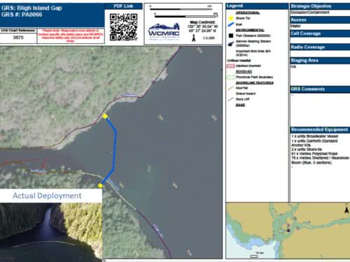
In the first days of the Bligh Island Shipwreck response, information from pre-planned Geographic Response Strategies (GRS) provided Unified Command with data and maps showing sensitive areas near Bligh Island. This critical information enabled responders to react quickly, deploying boom to protect those areas. GRS also gave Unified Command time to gather further, detailed information on areas of environmental, cultural and economic sensitivity identified by the Mowachat/Muchalaht First Nation, scientists and other specialists working with the incident management team.
About GRS:
Western Canada Marine Response’s Coastal Mapping Program combines environmental data and community input to identify and protect coastal sensitivities. The strategies, called Geographic Response Strategies (GRS’s), are mapped and stored in a database, which contains additional logistical, environmental and operational data for each site.
GRS’s protect elements of larger and smaller microhabitats rather than individual species. They are an emergency response tool created to safeguard archaeological and cultural sites, critical habitats and infrastructure, public beaches and parks, sensitive shorelines, and water-dependent commercial users.
GRS’s are operational documents that detail the location of vulnerable shoreline areas and describe how to protect them. Sensitive areas can be protected with boom secured to the shoreline or by on-water tactics that work to prevent or limit oil from reaching the shore.
GRS’s for the Bligh Island shipwreck are being further developed in collaboration between WCMRC, the Federal and Provincial governments, the Mowachat/Muchalaht First Nation, and industry.