
| SITREP | |
| Incident: | BLIGH ISLAND SHIPWRECK |
| Incident Start Date | DECEMBER 3, 2020 |
| Location: | BLIGH ISLAND, VANCOUVER ISLAND |
|
Situational Overview |
As a result of a number of sightings of sheening and oiling in the vicinity of Bligh Island / Zuciarte Channel, CCG confirms that the shipwreck of the M/V Schiedyk, a 483’ bulk carrier that sank in 1968, has started to release oil.
The situation escalated over (Dec 4-6), and heavy oil was observed on the water and staining rocks on the shoreline. As a result the Canadian Coast Guard (CCG) contracted the Western Canada Marine Response Corporation (WCMRC) to deploy to the area. CCG has established an Incident Command System (ICS) for this incident, with CCG as the Federal Incident Commander in this Unified command alongside Ministry of Environment and Climate Change Strategy and the Mowachaht/Muchalaht First Nation. Remotely operated vehicle (ROV) operations report that the product is seeping from more than one location and that vessel is resting hull-up in 350–400 ft. of water. M/V Schiedyk was carrying approximately 1000 tons of grain and pulp when it grounded. Oil type is yet to be confirmed but currently reported as heavy fuel oil. Samples have been sent to Environment and Climate Change Canada’s Pacific Environmental Science Center (PESC) and Emergencies Science and Technology Section (ESTS) laboratories from forensic chemistry and fate and behavior modeling. An analysis is pending. Upwelling is estimated at 1–4 L per hour but operations believe this may be increasing. Daily preventative actions are being taken to contain the immediate threats and prevent long-term damage to the environment. The incident public website is live. CCG has on going scheduled Transport Canada National Aerial Surveillance Program (NASP) overflights of the area. Drone operations continue. Large amount off-shore boom has been placed to assist with heavy fuel oil containment. South of the wreck site deflection booming has been set up. Numerous Geographic Response Strategy (GRS) boom has been implemented across ecological sensitive areas. |
| Incident Priorities |
|
| Agencies Involved (either in person or remote) |
|
Incident Management Team (IMT): UNIT UPDATES
OPERATIONS
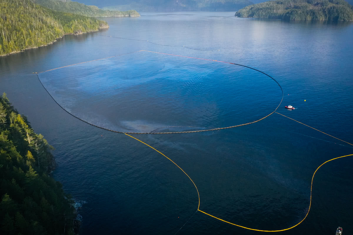
Summary: In-field operations to meet incident objectives are using a combination of floating, sub-sea and aerial resources. These resources provide direction daily, and conduct assignments like Aerial Observation, Protection Booming, Wreck Assessment, surface oil collection and recovery, as well as marine mammal and wildlife assessment. Operations staff are working out of Nootka Sound and Gold River, and following integrated Safety, Communications, and Logistical plans. Planning for these tactical operations is risk-based, and determined through a planning cycle. Equipment such as storage tanks/bins, consumable like Personal Protective Equipment (PPE) and sorbents, as well as additional equipment for contingencies, are stored at the incident staging area near Gold River. Weather, remoteness, and a consistent upwelling of oil continue to challenge in-field operations.
- General maintenance and inspection of boom including replacement of batteries and lights. Boom is holding no signs of entrainment or oil outside the boomed area. (2021-01-17)
- Marine Mammal Response boat with drone operating in view of shipwreck. PRV 668, 750 conducted various maintenance and inspection of boom. WCMRC conducted inspections of GRS . 2021-01-16)
- 750 ft of boom has been deployed in a U shape pattern for secondary containment south of the Ro-Boom. This should contain any entrainment. (2021-01-15)
- Weather hampered on-water operations in the forenoon (gusting >35 kts). All on-water ops stood down with crews conducting various training including First Response to Oil Spill Training (FROST), person in the water, SAR and First Aid. Safety lifted the stand down and at 13:00 crews were back on the water. (2021-01-14)
- Containment boom is fully enclosed now in the shape of a diamond. This should stop the sheen that was escaping over the North end of the RoBoom during an ebb tide. (2021-01-14)
- Bligh Island at the cut has been fully boomed to stop pollution from migrating up the cut. (2021-01-14)
- Tug Cadal and barge Miller 201 remain in transit, this afternoon was sheltering in Bull Harbour waiting for favourable weather conditions prior to transiting around northern tip and West Coast Vancouver Island. (2021-01-14)
- The Viking buoy is on a truck heading to Gold River and will arrive Friday morning. The Tully is scheduled to pick up from dock and position the buoy on Jan 17. (2021-01-14)
- Focus 1 took oil samples, will be delivered to laboratory on Thurs for further analysis. (2012-01-13)
- Drone operations this morning during a flood tide, noted that product was being pushed out the north end of the boom. (2021-01-13)
- West side shore line is keeping pocket in place to ensure shape is stable during flood tides. (2021-01-13)
- During the boom lifting operations today, the High Speed Sweep System (HSSS) was deployed with the assistance of the drone. Some oily product was captured. (2021-01-12)
- Atlantic Eagle was stood down from their SAR call and returned on site this morning at 0700 to help conduct the Ro-Boom deployment operations. (2021-01-12)
- Successful Ro-Boom deployment of 100 m section today off the Atlantic Eagle, reports of product escaping the Ro-Boom earlier this morning during the flood tide however, it was no longer visible in the afternoon and appears to have dissipated. Ro-Boom was placed in the pocket with the assistance of Sentinel vessels. (2021-01-12)
- Extra Ro-Boom anchors deployed. Position of boom is effective for containment. (2021-01-11)
- Boom was pushed up on shore again today; tide was the contributing factor and no damage to the boom.
(2021-01-11)
- South mooring line was shortened today by 30.5 m using the tug Nelson Mac, this helped keep the boom off the shore. (2021-01-11)
- East anchor was deployed with Nelson Mac and this mooring is keeping the boom off the shore line. (2021-01-11)
- Conducted log removal from the boom area. Most of the logs are coming from shore side between the deflection booms and the Ro-Boom. (2021-01-11)
- At 1622 it was reported that the boom has shifted. More information tomorrow as on-water operations are now completed for the day. Initial report indicates that the anchors holding the eastern terminus of the boom shifted allowing the eastern portion of boom to be pushed westward. Without the boom pocket holding the large U shape, it is no longer collecting or containing the oil. (2021-01-10)
LOGISTICS
Summary: This incident has challenged the Incident Command Post to find innovative ways to support responders at the remote incident site while also following COVID protocols. CCG and industry have integrated to bolster the existing communication network in the area to ensure responders have a safe and dependable means to communicate with each other and the virtual Incident Command Post. By cascading private/government equipment throughout Western Canada, responders have the on-water pollution counter measure equipment required. The current lack of tourism in the area allows responders to utilize lodging that had been shut down for the off-season.
- Confirmed Viking buoy in Gold River awaiting loading and deployment on Tully. (2021-01-17)
- Drift model buoys for data collection will be delivered 2017-01-17. (2021-01-16)
- Spot Beacons activated and ready for use between Campbell River and Gold River as part of an enhanced awareness and safety initiative. (2021-01-16)
- Viking buoy on the truck heading to Gold River. Will arrive Friday morning. Tully to pick up and deploy buoy Sunday. (2021-01-14)
- Investigating with Aids to Navigation about the potential for marking the entrance to Critter Cove. Various options such as lighted aid or day mark / temporary or permanent depending on the identified requirement. (2021-01-11)
- Atlantic Eagle successfully loaded RoBoom and departed Gold River. (2021-01-10)
AIR OPERATIONS
Summary: Weather within the steep mountains that surround Nootka Sound continue to challenge aerial observations. The incident is using both fixed and rotary wing manned aircraft to provide real-time observations to ground crews. Transport Canada’s National Aerial Surveillance Program (NASP) is able to quantify and outline the on-water oil. This information is then used to support recovery operations and future trajectory modelling. In addition to manned aircraft, Remotely Piloted Aircraft System (RPAS) teams from CCG and industry remain on scene to support individual task forces.
- NASP overflight conducted today. (2021-01-14)
- VIH Helicopters in the area today, 2 for logging, and one for crew movement. (2021-01-14)
- Drone conducted fly over of the booming operations today. (2021-01-13)
- NASP overflight conducted today, 2.7 L and 23.4 L of product observed. (2021-01-12)
- NASP overflight conducted today. Nothing to report from Bligh Island Incident. (2021-01-11)
- CCG Helo 435 noted some entrainment was noted, possibly due to the work conducted on the boom. Boom in place and holding. (2021-01-11)
BOOM IN PLACE. (2020-12-17)
- Mooyah Bay and Little Mooyah Bay GRSs have been removed. (2021-01-13)
| Coordinates | GRS Location | Length of Boom (feet) | Length of Boom (metres) |
| 49°38.49’N, 126°31.27’W | Ewin Inlet | 550 | 168 |
| 49°40.58’N, 126°28.21’W | Cheesish Reserve/Tuta Marina | 950 | 290 |
| 49°40.70’N, 126°28.59’W | Cheesish Reserve NW Bay | 2650 | 801 |
| 49°40.40’N, 126°28.08’W | Cheesish Reserve SE Bay | 1000 | 305 |
| 49°37.42’N, 126°31.02’W | Bligh Island Gap | 250 | 76 |
| 49°36.14’N, 126°37.06’W | Santa Gertrudis Cove | 800 | 243 |
| 49°38.15’N, 126°30.56’W | Upwelling Site Deflection | 1000 | 305 |
| Total Deployed | 10250 | 3124 |
OIL RECOVERED
(oil product recovered is mixed with salt water and/or organics)
| SOURCE | Amount |
| M/V Schiedyk | None |
| Surface Oil | Jan 10: 149 bags and 1 super sack
Jan 11: 36 bags Jan 12: 19 bags Jan 13: 2 bags Jan 14: N/A Jan 15: 1 bag
|
Environmental Unit (EU): UPDATES
Summary: All measures taken by the Incident Command Post utilize the Precautionary Approach and focused on minimizing damages and maximizing efforts. This approach to incident management relies on the Environmental Unit, which is comprised of Federal, Indigenous, Provincial and industry technical specialists and makes environmental-related recommendations to Unified Command that represents the interests of all contributing Environmental Unit members. An example of an ongoing agenda item for the Environmental Unit is the regular review and update of the ICS 232, a form that documents and prioritizes the Resources at Risk. Operations then use this prioritized list of environmental, economic and cultural sensitivities to build strategies and tactics to prevent damages. These proposed tactics are presented to the Unified Command for approval.
- Two Shoreline Clean-up Assessment (SCAT) teams commenced reconnaissance of the area of operation. Plan to survey approx 100 km of coastline. (2021-01-17)
- Marine Mammal Team survey drone footage shows containment booms are doing a good job near where the sea otters have been seen. This weekend the survey team was able to photo ID four separate humpback whales which have been in the area and have been tracking their movements. A lone killer whale was observed adjacent to the site. (2021-01-17)
- DFO continues liaison with Ops to find a suitable location lat/long to deploy the Viking Buoy. (2021-01-15)
- Pacific Environmental Science Center (PESC) has completed their analysis of the “source” sample, no PCBs were detected. (2021-01-14)
- Ewin Inlet observed some sheen in the inlet and oil on the boom. The EU recommends that the Ewin Inlet GRS stays in place. (2021-01-14)
- Focus Wildlife’s Migratory Bird Impact Assessment surveys for Jan 12/13 noted sporadic sheen along the centerline of the containment boom for the Ewin Inlet GRS. (2021-01-14)
- Focus Wildlife Impact Assessment for Jan 11 is completed. More than 2,100 individual birds across 32 species have been observed to-date. Marvinas Bay, Mooyah Bay, Hoiss Reserve, and Tsowwin Reserve have been identified as areas with higher abundance. (2021-01-12)
- A pod of 5 Orca whales were transiting East bound from Camel Rock in Hanna Channel at the top end of Bligh Island. (2021-01-12)
- Focus Wildlife’s migratory bird impact assessment for Jan 8-10 completed. More than 1,400 individual birds across 32 different species have been observed to date. (2021-01-11)
- No marine mammal survey conducted yesterday due to bad weather, but the marine mammal group was able to monitor the otter near the site. The sea otter was active and in the same location, no observable oil sheen near the otter. (2021-01-10)
| Wildlife Observations (accumulative from December 10, 2020) | ||
| Wildlife Species | Verified Impacted | Observed |
| Sea Otter | 1 | 1 in the immediate area (2021-01-13).
92 in the larger area. |
| Great Blue Heron | 1 | |
| Harbour Seal | 1 (Transiting through area. Likely minimal impact) | |
| Stellar Sea Lion | 1 (Transiting through area. Likely minimal impact) | |
| Baleen Whale | 1 Humpback (2021-01-13)
2 Humpbacks (2021-01-10) Pod of Orcas (5) spotted (2021-01-12) |
|
ASSIGNED RESOURCES:
Vessels:
- ETV ATL EAGLE – On Water Branch Director
- CCGS Moorhen (RHIB)
- CGE 750 (PRV III)
- CGE 668 (PRV III)
- MCI Landing Craft “SeaTruck1” with Drone
- DFO Vessel “Marine Mammal Response”
- WCMRC – Cortes Sentinel
- SNRC Hydra Vessel (Strategic) with Drone (WCMRC Contracted)
- “Rapid Warrior” Tug (CCG Contracted)
- Grieg Seafood Contracted Vessel and assist Tug “Nelson Mac”
- Focus Wildlife “Focus 1”
Equipment:
- Current Buster 2 (NOFI) – Anchored in “Helipad Bay”
- Triton 20 Skimmer – on CGE 668
- RO Boom: 3,300 ft
- GP Boom: 1,200 ft
- Total Boom Deployed to Field: 10,350 ft
- GRS: 9,250 ft
- Deflection: 700 ft
- Decon Ponding: 400 ft
- Total Boom Disposed of: 3,650 ft